1
Crocodile teeth at the entrance to Pencoed Park & Ride
Cars can enter the Park and Ride http://www.geograph.org.uk/photo/4240476 between 7am and 6pm. The gate is locked across the left side at 6pm. Metal crocodile teeth on the traffic flow plate can move only towards the camera, so cars can exit at any time, whereas a vehicle attempting to enter on the right will have multiple punctures.
Image: © Jaggery
Taken: 9 Nov 2014
0.04 miles
2
The New Surgery, Pencoed
Built during 2011, The New Surgery Primary Care Centre is in Min-y-Nant.
Image: © Jaggery
Taken: 9 Nov 2014
0.04 miles
3
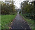
Path to Pencoed railway station
From the south side of the street named Min-y-Nant, near the Park & Ride entrance. http://www.geograph.org.uk/photo/4240498
Image: © Jaggery
Taken: 9 Nov 2014
0.05 miles
4
Pencoed Allotments entrance gate
From Min-y-Nant on the west side of the allotments which occupy land adjacent to the railway near Pencoed Station.
Image: © Jaggery
Taken: 9 Nov 2014
0.07 miles
5
Scout hall in Pencoed
Viewed across Min-y-Nant. The name on the side wall is 1st Pencoed Scout Group.
Image: © Jaggery
Taken: 9 Nov 2014
0.07 miles
6
Pencoed allotments
Located between Pencoed railway station platform 2 on this side and the street named Min-y-Nant on the far side. The allotments entrance gate http://www.geograph.org.uk/photo/4240530 is from Min-y-Nant.
Image: © Jaggery
Taken: 9 Nov 2014
0.07 miles
7
Pencoed Park & Ride
Opened in June 2011, the 56-space Park & Ride is located near Pencoed Railway Station, viewed from Min-y-Nant. There were several reasons for the creation of the facility, such as reducing inconsiderate parking near the station, reducing the need for drivers to use the level crossing (between the eastbound platform and the westbound platform at the station), and to encourage the use of the railway.
Image: © Jaggery
Taken: 9 Nov 2014
0.08 miles
8
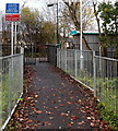
Path to platform 2, Pencoed railway station
From the street named Min-y-Nant. Platform 2 is for eastbound trains, towards Cardiff and Newport.
Image: © Jaggery
Taken: 9 Nov 2014
0.08 miles
9
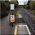
Passengers must not cross the line, Pencoed
At the northeast end of Pencoed railway station platform 2.
The path on the left leads to Penprysg Road. Penprysg Road bridge is in the distance.
Image: © Jaggery
Taken: 9 Nov 2014
0.08 miles
10
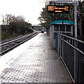
Electronic display board, platform 2, Pencoed railway station
This platform is for eastbound trains, towards Cardiff and Newport.
Platform 1 for trains towards Bridgend and Swansea is about 200 metres ahead,
on the far side of Hendre Road level crossing, beyond the distant footbridge.
Image: © Jaggery
Taken: 9 Nov 2014
0.09 miles


