1
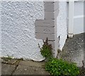
Ordnance Survey Cut Mark
This OS cut mark can be found on No28 Hendre Road. It marks a point 37.192m above mean sea level.
Image: © Adrian Dust
Taken: 26 May 2018
0.13 miles
2
Hendre Road west of Min-y-Nant, Pencoed
From the corner of Min-y-Nant. http://www.geograph.org.uk/photo/4242366
Image: © Jaggery
Taken: 9 Nov 2014
0.15 miles
3
Fenced-off electricity substation near Hendre Road, Pencoed
The Western Power Distribution electricity substation is in a lane on the south side of Hendre Road.
Image: © Jaggery
Taken: 9 Nov 2014
0.18 miles
4
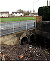
Stream culverts, Pencoed
The stream Nant Heol y Geifr emerges from twin culverts under Hendre Road.
Image: © Jaggery
Taken: 9 Nov 2014
0.19 miles
5
Bridgend District : The M4 Motorway
The M4 Motorway seen as it passes through the Bridgend area.
Image: © Lewis Clarke
Taken: 10 Apr 2014
0.20 miles
6
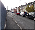
Goat Road, Pencoed
Houses on the west side of Goat Road face the perimeter fence enclosing waste ground. http://www.geograph.org.uk/photo/4242350
Image: © Jaggery
Taken: 9 Nov 2014
0.20 miles
7
Southern end of Min-y-Nant, Pencoed
The road named Min-y-Nant heads north away from Hendre Road.
Image: © Jaggery
Taken: 9 Nov 2014
0.22 miles
8
Western end of Coed y Graig, Pencoed
Viewed across Min-y-Nant.
Image: © Jaggery
Taken: 9 Nov 2014
0.23 miles
9
Waste ground on the east side of Goat Road, Pencoed
The fenced-off site, about 120 metres by 70 metres, is between Goat Road and railway lines.
It looks likes the site of a demolished factory.
Image: © Jaggery
Taken: 9 Nov 2014
0.24 miles
10
Heol Fach electricity substation, Pencoed
The Western Power Distribution electricity substation is located between houses in Heol Fach
and Parc-y-Rhos. A yellow triangle on the substation shows the presence of SF6
(sulphur hexafluoride, an insulating gas used in high voltage systems).
Image: © Jaggery
Taken: 9 Nov 2014
0.24 miles


