IMAGES TAKEN NEAR TO
Heol Mathews, BRIDGEND, CF35 6JU
Introduction
This page details the photographs taken nearby to Heol Mathews, CF35 6JU by members of the Geograph project.
The Geograph project started in 2005 with the aim of publishing, organising and preserving representative images for every square kilometre of Great Britain, Ireland and the Isle of Man.

There are currently over 7.5m images from over14,400 individuals and you can help contribute to the project by visiting https://www.geograph.org.uk
Image Map
Images are licensed for reuse under creativecommons.org/licenses/by-sa/2.0
Notes
- Clicking on the map will re-center to the selected point.
- The higher the marker number, the further away the image location is from the centre of the postcode.
Image Listing (5 Images Found)
Images are licensed for reuse under creativecommons.org/licenses/by-sa/2.0
Image
Details
Distance
1
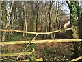
Brackla Woodlands
Woodlands on the edge of the Brackla housing estate.
Image: © Alan Hughes
Taken: 24 Feb 2017
0.07 miles
2
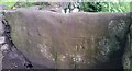
Ordnance Survey Cut Mark
This OS cut mark can be found on the stile NE side of the road. It marks a point 58.892m above mean sea level.
Image: © Adrian Dust
Taken: 26 May 2018
0.12 miles
3
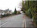
Houses on the south side of Heol Yr Ysgol, Coity
Looking southwestwards, towards the Six Bells. http://www.geograph.org.uk/photo/1689681
Image: © Jaggery
Taken: 26 Oct 2009
0.24 miles
4
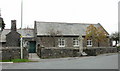
St Mary's church hall, Coity
The hall of St Mary the Virgin church. http://www.geograph.org.uk/photo/1689739
Image: © Jaggery
Taken: 26 Oct 2009
0.25 miles
5
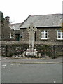
Celtic Cross war memorial, Coity
Located in front of St Mary's church hall. http://www.geograph.org.uk/photo/1689765
On the column of the cross are recorded the names of the men of the parish who fell in the Great War 1914-1918.
On the base of the cross are recorded the names of those who fell in the Second World War 1939-1945.
Image: © Jaggery
Taken: 26 Oct 2009
0.25 miles