IMAGES TAKEN NEAR TO
Blackmill, BRIDGEND, CF35 6DP
Introduction
This page details the photographs taken nearby to CF35 6DP by members of the Geograph project.
The Geograph project started in 2005 with the aim of publishing, organising and preserving representative images for every square kilometre of Great Britain, Ireland and the Isle of Man.

There are currently over 7.5m images from over14,400 individuals and you can help contribute to the project by visiting https://www.geograph.org.uk
Image Map (Loading...)


Getting Data...Please wait
Leaflet Map data © OpenStreetMap
Images are licensed for reuse under creativecommons.org/licenses/by-sa/2.0
Notes
- Clicking on the map will re-center to the selected point.
- The higher the marker number, the further away the image location is from the centre of the postcode.
Image Listing (67 Images Found)
Images are licensed for reuse under creativecommons.org/licenses/by-sa/2.0
Image
Details
Distance
1
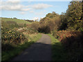
National Cycle Route 4 just south of Blackmill
A picture taken on that part of the long distance cycle route where it passes along a stretch of the Ogmore Valley cycle path/community route. At Blackmill, this cycle path becomes National Cycle Network Route 883, while Route 4 switches to the valley Cwm Ogwr Fach.
Image: © eswales
Taken: 25 Oct 2013
0.06 miles
2
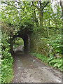
Rail Bridge at Nant Cwm Dwr
This bridge carried the line from nearby Blackmill to Heol-Y-Cyw
Image: © John Finch
Taken: 12 Aug 2012
0.06 miles
3
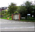
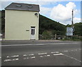
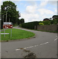
Blackmill Hill bus stop and shelter near Blackmill
On the corner of the A4061 and the minor road to Buarthau. In August 2018 the timetable on the bus stop pole shows that this is stop on First Cymru bus routes 74 and 75 to Bridgend via Bryncethin and Sarn.
Image: © Jaggery
Taken: 25 Aug 2018
0.08 miles
4
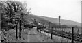
Blackmill Station
View SW, towards Tondu and Bridgend; Bridgend - Tondu - Nantymoel/Gilfach Goch lines. Service cut back from Gilfach Goch 22/9/30 (goods 5/6/61). Station closed to passengers 5/5/58, to goods 27/3/61. Coal traffic from the Ogmore Valley line through Blackmill continued until at 11/62, possibly 9/64: the line certainly seemed to be still in use in 6/62 - precise dates of line closure are uncertain.
Image: © Ben Brooksbank
Taken: 1 Jun 1962
0.08 miles
5
A4061 direction and distances signs on the approach to Blackmill
Alongside the A4061 near the minor road from Buarthau, 5 miles from Bridgend
(Pen-y-bont in Welsh), 4 from Nantymoel and 5 from Tonyrefail (via the A4093).
Image: © Jaggery
Taken: 25 Aug 2018
0.08 miles
6
Blackmill Woodlands information board beside National Cycle Route 4
The board provides information about the local sessile oak woodlands which are designated a Site of Special Scientific Interest and a Special Area of Conservation. Parts of these woodlands can be seen in Image and Image
Image: © eswales
Taken: 25 Oct 2013
0.10 miles
7
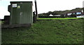
Wales & West Utilities gas installation on a bank above the A4061, Blackmill
Located between the A4061 and Dan-y-Coed. A notice on the installation showing EX indicates a potentially explosive atmosphere - no smoking on or near this site.
Image: © Jaggery
Taken: 25 Aug 2018
0.11 miles
8
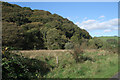
The eastern end of Coedtal-y-fan by Blackmill
A view from the Ogmore Valley cycle path showing the eastern end of Coedtal-y-fan, an area of ancient woodland, approximately 0.8 miles (1.3 kilometres) long, on the hillside Craig Tal-y-fan, near Blackmill. The trees here are mainly sessile oaks.The woodland is designated a Site of Special Scientific Interest and a Special Area of Conservation.
Image: © eswales
Taken: 25 Oct 2013
0.11 miles
9
Minor road to Buarthau near Blackmill
Viewed from near the corner of the A4061. The road also leads to Heron's Brook and Dan-y-coed.
Image: © Jaggery
Taken: 25 Aug 2018
0.12 miles
10
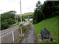
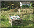
Memorial bench facing the A4061, Blackmill
The plaque on the bench shows IN MEMORY OF JONPAUL BAKER.
Image: © Jaggery
Taken: 25 Aug 2018
0.12 miles