IMAGES TAKEN NEAR TO
Llys Tysant, BRIDGEND, CF35 6AZ
Introduction
This page details the photographs taken nearby to Llys Tysant, CF35 6AZ by members of the Geograph project.
The Geograph project started in 2005 with the aim of publishing, organising and preserving representative images for every square kilometre of Great Britain, Ireland and the Isle of Man.

There are currently over 7.5m images from over14,400 individuals and you can help contribute to the project by visiting https://www.geograph.org.uk
Image Map
Images are licensed for reuse under creativecommons.org/licenses/by-sa/2.0
Notes
- Clicking on the map will re-center to the selected point.
- The higher the marker number, the further away the image location is from the centre of the postcode.
Image Listing (35 Images Found)
Images are licensed for reuse under creativecommons.org/licenses/by-sa/2.0
Image
Details
Distance
1
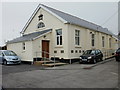
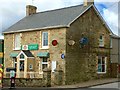
Gilead chapel hall, Coity
Located alongside Gilead chapel http://www.geograph.org.uk/photo/1690859 on Heol Spencer, Coity. The hall opened in 1938.
Image: © Jaggery
Taken: 26 Oct 2009
0.08 miles
2
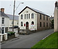
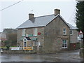
Gilead Chapel, Coity, Bridgend
Located on Heol Spencer, Coity.
The original chapel was built here in 1826. In 1862 it was rebuilt and extended.
In 1890 it was rebuilt again and looks today much as it did in that year.
Image: © Jaggery
Taken: 26 Oct 2009
0.08 miles
3
Pwll-Evan-Ddu, Coity, Bridgend
Viewed from Heol West Plas.
Image: © Jaggery
Taken: 26 Oct 2009
0.08 miles
4
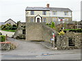
Llys Tysant, Coity, Bridgend
Viewed from Heol West Plas.
Image: © Jaggery
Taken: 26 Oct 2009
0.08 miles
5
St Christopher's Court, Coity, Bridgend
Viewed from Heol West Plas.
Image: © Jaggery
Taken: 26 Oct 2009
0.11 miles
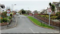
6
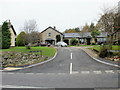
West Plas Road, Coity
Although now a suburb of Bridgend, Coity retains a village atmosphere with the added attraction of its fine ruined castle. In this view the post office is on the right.
Image: © Stephen McKay
Taken: 30 May 2016
0.13 miles
7
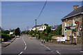
Coity Post Office
The Post Office, Coity.
Image: © Alan Hughes
Taken: 7 Mar 2016
0.13 miles
8
Coity: the post office
A village store and post office serving this small-ish village, viewed on a horribly wet morning.
Image: © Chris Downer
Taken: 18 Feb 2012
0.13 miles
9
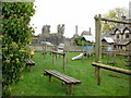
Play area, Heol Spencer, Coity
Children's play area in an elevated location on the east side of Heol Spencer, close to the Heol West Plas junction. Part of the ruins of Coity Castle are visible in the distance. http://www.geograph.org.uk/photo/1689628
Image: © Jaggery
Taken: 26 Oct 2009
0.14 miles
10

Ordnance Survey Cut Mark
This OS cut mark can be found on No1 Chapel Row. It marks a point 73.234m above mean sea level.
Image: © Adrian Dust
Taken: 26 May 2018
0.15 miles