IMAGES TAKEN NEAR TO
Heol Hopcyn John, BRIDGEND, CF35 6AR
Introduction
This page details the photographs taken nearby to Heol Hopcyn John, CF35 6AR by members of the Geograph project.
The Geograph project started in 2005 with the aim of publishing, organising and preserving representative images for every square kilometre of Great Britain, Ireland and the Isle of Man.

There are currently over 7.5m images from over14,400 individuals and you can help contribute to the project by visiting https://www.geograph.org.uk
Image Map (Loading...)


Getting Data...Please wait
Leaflet Map data © OpenStreetMap
Images are licensed for reuse under creativecommons.org/licenses/by-sa/2.0
Notes
- Clicking on the map will re-center to the selected point.
- The higher the marker number, the further away the image location is from the centre of the postcode.
Image Listing (16 Images Found)
Images are licensed for reuse under creativecommons.org/licenses/by-sa/2.0
Image
Details
Distance
1

Ordnance Survey Cut Mark
This OS cut mark can be found on the wall west side of the road. It marks a point 105.482m above mean sea level.
Image: © Adrian Dust
Taken: 5 Sep 2021
0.05 miles

4
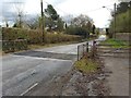
Cattle Grid
Cattle grid on the road to Coity.
Image: © Alan Hughes
Taken: 7 Mar 2016
0.12 miles
5
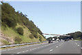
M4 immediately east of Junction 36
End of slip road can be seen on left
Image: © John Firth
Taken: 5 Sep 2012
0.14 miles
6
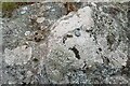
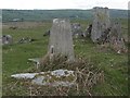
Ordnance Survey Rivet
This damaged OS rivet can be found on the rock outcrop on Cefn Hirgoed. It marks a point 130.186m above mean sea level.
Image: © Adrian Dust
Taken: 5 Sep 2021
0.16 miles
9

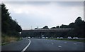
Bridgend District : The M4 Motorway
The M4 Motorway heading eastbound as it passes through the Bridgend area.
Image: © Lewis Clarke
Taken: 11 Apr 2014
0.16 miles
10
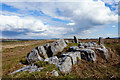
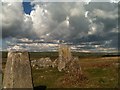
Stones at Cefn Hirgoed
Stones and a trig point on the common N of the M4 nr Jct 36 and Coity
Image: © John Finch
Taken: 13 Apr 2016
0.17 miles