IMAGES TAKEN NEAR TO
The Green, BRIDGEND, CF35 5PS
Introduction
This page details the photographs taken nearby to The Green, CF35 5PS by members of the Geograph project.
The Geograph project started in 2005 with the aim of publishing, organising and preserving representative images for every square kilometre of Great Britain, Ireland and the Isle of Man.

There are currently over 7.5m images from over14,400 individuals and you can help contribute to the project by visiting https://www.geograph.org.uk
Image Map
Images are licensed for reuse under creativecommons.org/licenses/by-sa/2.0
Notes
- Clicking on the map will re-center to the selected point.
- The higher the marker number, the further away the image location is from the centre of the postcode.
Image Listing (102 Images Found)
Images are licensed for reuse under creativecommons.org/licenses/by-sa/2.0
Image
Details
Distance
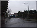
1
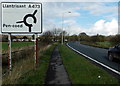
Direction sign near Pencoed
Alongside the A473 east of Pencoed. The sign uses the Welsh Pen-coed. Pencoed is more usual in English.
Image: © Jaggery
Taken: 9 Nov 2014
0.07 miles
2
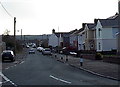
Glanyrafon Road, Pencoed
Looking south along Glanyrafon Road from the corner of Penybont Road.
Image: © Jaggery
Taken: 9 Nov 2014
0.11 miles
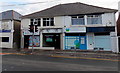
3
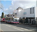
Pencoed Library and bus stop
Part of Bridgend Library and Information Service, Pencoed Library is located on Penybont Road.
The bus waiting at the bus stop is on a First route 44 service from Talbot Green to Bridgend. The route is shared with Veolia, who run the evening services.
Image: © Jaggery
Taken: 12 Feb 2011
0.13 miles
4
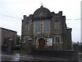
Trinity Presbyterian Church of Wales, Pencoed
Image: © John Lord
Taken: 18 Mar 2010
0.13 miles
5
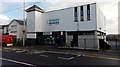
Pencoed Library
Part of Bridgend County Borough Council's library service, viewed across Penybont Road.
Image: © Jaggery
Taken: 9 Nov 2014
0.14 miles
6
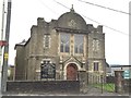
Trinity Presbyterian Church, Pencoed
Trinity Presbyterian Church, Pencoed.
Image: © Alan Hughes
Taken: 15 Apr 2016
0.14 miles
7
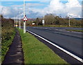
End of the dual carriageway section of the A473, Pencoed
The grass strip separating the carriageways ends on the right.
The triangular sign with two opposing black arrows draws attention to the change.
Image: © Jaggery
Taken: 9 Nov 2014
0.14 miles
8
Spiceland, Pencoed
Indian and Bangladeshi cuisine restaurant at 46 Penybont Road. Pencoed Library http://www.geograph.org.uk/photo/4238791 is on the left.
Image: © Jaggery
Taken: 9 Nov 2014
0.14 miles
9
Bridge over the railway, Penprysg Rd, Pencoed
Image: © John Lord
Taken: 18 Mar 2010
0.14 miles
10
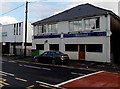
Glamorgan Physiotherapy Clinic in Pencoed
The clinic entrance is the blue door at 42 Penybont Road.
Image: © Jaggery
Taken: 9 Nov 2014
0.14 miles