1
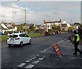
Direction signs, Coychurch Road, Pencoed
Facing the Felindre Road junction.
Image: © Jaggery
Taken: 9 Nov 2014
0.04 miles
2
Waiting for the Remembrance Day Parade in Pencoed
On the corner of Coychurch Road and St John's Drive, the men on the left look towards the approaching parade. http://www.geograph.org.uk/photo/4520913
Image: © Jaggery
Taken: 9 Nov 2014
0.04 miles
3
Remembrance Day car in Coychurch Road, Pencoed
On Remembrance Sunday, November 9th 2014, two loudspeakers
on the back of the car broadcast the music for the following parade. http://www.geograph.org.uk/photo/4520913
Image: © Jaggery
Taken: 9 Nov 2014
0.04 miles
4
Back of the Remembrance Sunday Parade in Pencoed
On Remembrance Sunday, November 9th 2014, the parade heads along Coychurch Road towards the War Memorial. http://www.geograph.org.uk/photo/2268432
Image: © Jaggery
Taken: 9 Nov 2014
0.04 miles
5
Bryn Seion chapel, Pencoed
Chapel on the east side of Coychurch Road, between Felindre Road and Glossop Terrace. The date stone above the topmost window shows 1897. It opened as a Congregational chapel in 1898.
Image: © Jaggery
Taken: 12 Feb 2011
0.04 miles
6
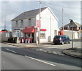
The Corner Shop, Pencoed
Located on the corner of Glossop Terrace, viewed across Coychurch Road.
Image: © Jaggery
Taken: 12 Feb 2011
0.04 miles
7
Remembrance Day Parade in Pencoed
On Remembrance Sunday, November 9th 2014, the parade heads along Coychurch Road towards the War Memorial. http://www.geograph.org.uk/photo/2268432
Image: © Jaggery
Taken: 9 Nov 2014
0.05 miles
8
Railway towards Bridgend from Pencoed
Viewed from Pencoed railway station platform 1.
Image: © Jaggery
Taken: 9 Nov 2014
0.05 miles
9
Waste ground on the east side of Goat Road, Pencoed
The fenced-off site, about 120 metres by 70 metres, is between Goat Road and railway lines.
It looks likes the site of a demolished factory.
Image: © Jaggery
Taken: 9 Nov 2014
0.06 miles
10
Former Bryn Seion chapel, Pencoed
Viewed across Coychurch Road in early November 2014. The date stone above the topmost window shows 1897. It opened as a Congregational chapel in 1898. The building has not been used for worship for some time. Bridgend County Borough Council records show that in November 2013, a planning application to "convert semi derelict chapel into 4 bedroom dwelling" was accepted.
Image: © Jaggery
Taken: 9 Nov 2014
0.06 miles


