1
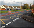
Coychurch Road closed ahead, Pencoed
For the Remembrance Sunday Parade on November 9th 2014. http://www.geograph.org.uk/photo/4520913
Image: © Jaggery
Taken: 9 Nov 2014
0.02 miles
2
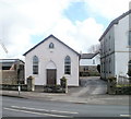
Salem Chapel vestry, Pencoed
On Coychurch Road, located next to the Grade II listed chapel. http://www.geograph.org.uk/photo/2267937
A vestry is used for keeping vestments, vessels, records, etc, and as a robing-room. This vestry is also used for various community functions and is the meeting place for the local girl guides.
Image: © Jaggery
Taken: 12 Feb 2011
0.02 miles
3
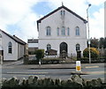
Salem Chapel, Pencoed
Grade II listed Welsh Calvinist Methodist chapel, Coychurch Road. It was opened in 1888 on the site of two previous chapels. The original chapel was set up in 1775, the first Methodist chapel in Glamorgan. In 1830 a larger chapel was built on the same site, with a seating capacity said to be 500.
On the left is the chapel vestry. http://www.geograph.org.uk/photo/2267954
Image: © Jaggery
Taken: 12 Feb 2011
0.02 miles
4
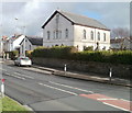
Salem Chapel and Vestry, Pencoed
The chapel http://www.geograph.org.uk/photo/2267937 and vestry http://www.geograph.org.uk/photo/2267954 are on Coychurch Road.
Image: © Jaggery
Taken: 12 Feb 2011
0.02 miles
5
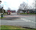
Entrance to two schools, Coychurch Road, Pencoed
Viewed across Coychurch Road from the edge of Hafod Las. The entrance road is into Pencoed Comprehensive School and Croesty Primary School.
Image: © Jaggery
Taken: 12 Feb 2011
0.04 miles
6
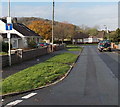
Hafod Las, Pencoed
On the west side of Coychurch Road.
Image: © Jaggery
Taken: 9 Nov 2014
0.05 miles
7
Hafod Las bungalows, Pencoed
Bungalows on the north side of Hafod Las, viewed from near the edge of Ton Teg. http://www.geograph.org.uk/photo/2267847
Image: © Jaggery
Taken: 12 Feb 2011
0.05 miles
8
Maximum speed 5mph in the school grounds, Pencoed
Coychurch Road entrance to two schools, Pencoed Comprehensive School and Croesty Primary School.
Image: © Jaggery
Taken: 9 Nov 2014
0.05 miles
9
Ton Teg and Hafod Las, Pencoed
Looking along Hafod Las from the edge of Coychurch Road. Hafod Las continues on the right (north) ; Ton Teg is on the left
Image: © Jaggery
Taken: 12 Feb 2011
0.06 miles
10
Coychurch Road pedestrian refuge and red pillarbox, Pencoed
The pillarbox http://www.geograph.org.uk/photo/4520959 bears the ERII insignia.
Image: © Jaggery
Taken: 9 Nov 2014
0.06 miles


