IMAGES TAKEN NEAR TO
St. Mary Hill, BRIDGEND, CF35 5EB
Introduction
This page details the photographs taken nearby to CF35 5EB by members of the Geograph project.
The Geograph project started in 2005 with the aim of publishing, organising and preserving representative images for every square kilometre of Great Britain, Ireland and the Isle of Man.

There are currently over 7.5m images from over14,400 individuals and you can help contribute to the project by visiting https://www.geograph.org.uk
Image Map
Images are licensed for reuse under creativecommons.org/licenses/by-sa/2.0
Notes
- Clicking on the map will re-center to the selected point.
- The higher the marker number, the further away the image location is from the centre of the postcode.
Image Listing (3 Images Found)
Images are licensed for reuse under creativecommons.org/licenses/by-sa/2.0
Image
Details
Distance
2
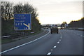
Rhondda Cynon Taf : M4 Motorway
The M4 Motorway with a sign in view as we approach junction 35.
Image: © Lewis Clarke
Taken: 10 Apr 2014
0.17 miles
3
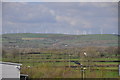
Rhondda Cynon Taf : Countryside Scenery
Looking towards the hillsides and a wind farm in the Rhondda Cynon Taf area.
Image: © Lewis Clarke
Taken: 11 Apr 2014
0.20 miles