IMAGES TAKEN NEAR TO
St. Mary Hill, BRIDGEND, CF35 5BY
Introduction
This page details the photographs taken nearby to CF35 5BY by members of the Geograph project.
The Geograph project started in 2005 with the aim of publishing, organising and preserving representative images for every square kilometre of Great Britain, Ireland and the Isle of Man.

There are currently over 7.5m images from over14,400 individuals and you can help contribute to the project by visiting https://www.geograph.org.uk
Image Map
Images are licensed for reuse under creativecommons.org/licenses/by-sa/2.0
Notes
- Clicking on the map will re-center to the selected point.
- The higher the marker number, the further away the image location is from the centre of the postcode.
Image Listing (9 Images Found)
Images are licensed for reuse under creativecommons.org/licenses/by-sa/2.0
Image
Details
Distance
2
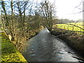
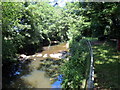
Ewenny River
Ewenny river near Tan y Lan.
Image: © Alan Hughes
Taken: 3 Mar 2016
0.04 miles
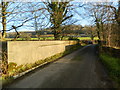
3

Ordnance Survey Cut Mark
This OS cut mark can be found on the SW parapet of the bridge. It marks a point 23.332m above mean sea level.
Image: © Adrian Dust
Taken: 20 May 2018
0.06 miles
6
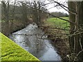
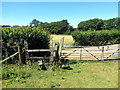
Afon Ewenni / Ewenny River
Llecyn glas ar lan Afon Ewenni sy'n boblogaidd gan bysgotwyr mae'n debyg. Heddi mae'r afon yn isel iawn.
A green area above the Ewenny river popular with anglers it seems. Today the river is very low.
Image: © Alan Richards
Taken: 27 Jun 2018
0.12 miles
7

Ordnance Survey Cut Mark
This OS cut mark can be found on a concrete post near the ford. It marks a point 21.839m above mean sea level.
Image: © Adrian Dust
Taken: 20 May 2018
0.12 miles
9
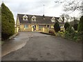
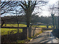
Llwybr yn cyrraedd yr heol / A path joining a road
Llwybr cyhoeddus yn cyraedd heol fach.
A public footpath joining a minor road.
Image: © Alan Richards
Taken: 27 Jun 2018
0.14 miles