IMAGES TAKEN NEAR TO
Parklands, BRIDGEND, CF35 5BE
Introduction
This page details the photographs taken nearby to Parklands, CF35 5BE by members of the Geograph project.
The Geograph project started in 2005 with the aim of publishing, organising and preserving representative images for every square kilometre of Great Britain, Ireland and the Isle of Man.

There are currently over 7.5m images from over14,400 individuals and you can help contribute to the project by visiting https://www.geograph.org.uk
Image Map (Loading...)


Getting Data...Please wait
Leaflet Map data © OpenStreetMap
Images are licensed for reuse under creativecommons.org/licenses/by-sa/2.0
Notes
- Clicking on the map will re-center to the selected point.
- The higher the marker number, the further away the image location is from the centre of the postcode.
Image Listing (25 Images Found)
Images are licensed for reuse under creativecommons.org/licenses/by-sa/2.0
Image
Details
Distance
1
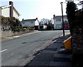
Parklands, Corntown
Cul-de-sac on the south side of the B4524 Corntown Road.
Image: © Jaggery
Taken: 30 Mar 2014
0.03 miles
2
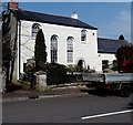
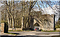
Former Bethlehem Baptist Church, Corntown
Now in secular use and named Tŷ Capel (Welsh for Chapel House), built in 1841 on the north side
of Corntown Road as Bethlehem Baptist Church. The former baptismal pool http://www.geograph.org.uk/photo/4107791 is nearby.
Image: © Jaggery
Taken: 30 Mar 2014
0.04 miles
3
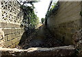
Public footpath towards Chapel Wood, Corntown
The slab in the foreground, about 2' (c 60cm) high, is across the whole width of the path, presumbly to deter vehicular misuse of the public footpath. Access from Corntown Road is from the western edge of this http://www.geograph.org.uk/photo/4243905 former Baptist Church a few metres behind the camera.
Image: © Jaggery
Taken: 30 Mar 2014
0.06 miles
4
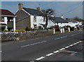
Corntown Road houses, Corntown
On the north side of the B4524 Corntown Road, viewed looking east from the corner of Parklands. http://www.geograph.org.uk/photo/4244015
Image: © Jaggery
Taken: 30 Mar 2014
0.07 miles
5
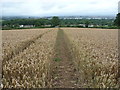
Corn fields above Corntown
What more appropriate land use could there be here?
Image: © Jeremy Bolwell
Taken: 10 Aug 2011
0.07 miles
7
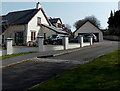
Little Acre, Corntown
Cul-de-sac on the south side of the B4524 Corntown Road.
Image: © Jaggery
Taken: 30 Mar 2014
0.08 miles
8
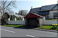
Late March in Corntown
On a sunny day in late March 2014, daffodils are in flower near a Corntown Road bus shelter.
Image: © Jaggery
Taken: 30 Mar 2014
0.08 miles
9

Ysbwriel is Welsh for litter, Corntown
The bilingual litter bin is on the corner of The Meadows and Corntown Road.
Image: © Jaggery
Taken: 30 Mar 2014
0.10 miles
10
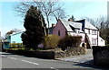
Pink house in Corntown
On the south side of the B4524 Corntown Road, viewed from the corner of The Meadows. http://www.geograph.org.uk/photo/4107766
Image: © Jaggery
Taken: 30 Mar 2014
0.11 miles