1
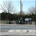
B4265 cabinets and direction signs at a Ewenny junction
Viewed from Wick Road. Turn right for Bridgend, left for Ogmore-by-Sea, Southerndown and Llantwit Major.
Image: © Jaggery
Taken: 30 Mar 2014
0.01 miles
2
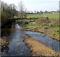
Ewenny River pipe bridge, Ewenny
35 metres west of Ewenny (road) Bridge, a bridge supports a pipe over the Ewenny River.
Image: © Jaggery
Taken: 30 Mar 2014
0.02 miles
3
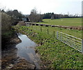
Field gates and a pipeline at the edge of the Ewenny River, Ewenny
The pipeline behind the gates is supported by a river bridge across the Ewenny ahead. http://www.geograph.org.uk/photo/4326484
Image: © Jaggery
Taken: 30 Mar 2014
0.02 miles
4
Wick Road side of Ewenny Garden Centre
This is the north side of the garden centre which occupies a large site, formerly named Bridge Farm Nurseries Garden Centre, in Bridgend County Borough near the Vale of Glamorgan boundary.
Satchells hair salon is on the left.
Image: © Jaggery
Taken: 30 Mar 2014
0.03 miles
5
Wick Rd, Ewenny, approaching the junction with Abbey Rd
Image: © John Lord
Taken: 18 Jun 2012
0.03 miles
6
Junction in Ewenny
Abbey Road on the left leads to the 12th century Priory Church. The B4524 Wick Road is on the right.
Image: © Jaggery
Taken: 30 Mar 2014
0.04 miles
7
Ordnance Survey Rivet
This OS rivet can be found on the east parapet of the bridge. It marks a point 10.146m above mean sea level.
Image: © Adrian Dust
Taken: 13 May 2018
0.04 miles
8
Water marker on Ewenny Bridge, Ewenny
http://www.geograph.org.uk/photo/4326457 to a closer view of the Glamorgan Fire Service water marker.
Image: © Jaggery
Taken: 30 Mar 2014
0.04 miles
9
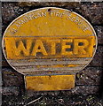
Glamorgan Fire Service water marker, Ewenny
On Ewenny Bridge http://www.geograph.org.uk/photo/4326462 over the Ewenny River. Glamorgan Fire Service no longer exists.
Ewenny is now part of the large area covered by the South Wales Fire and Rescue Service.
Image: © Jaggery
Taken: 30 Mar 2014
0.04 miles
10
Pipeline over the Ewenny River
Image: © Mick Lobb
Taken: 13 Jan 2009
0.04 miles


