IMAGES TAKEN NEAR TO
Hartland Road, CARDIFF, CF3 4JL
Introduction
This page details the photographs taken nearby to Hartland Road, CF3 4JL by members of the Geograph project.
The Geograph project started in 2005 with the aim of publishing, organising and preserving representative images for every square kilometre of Great Britain, Ireland and the Isle of Man.

There are currently over 7.5m images from over14,400 individuals and you can help contribute to the project by visiting https://www.geograph.org.uk
Image Map
Images are licensed for reuse under creativecommons.org/licenses/by-sa/2.0
Notes
- Clicking on the map will re-center to the selected point.
- The higher the marker number, the further away the image location is from the centre of the postcode.
Image Listing (5 Images Found)
Images are licensed for reuse under creativecommons.org/licenses/by-sa/2.0
Image
Details
Distance
1
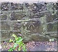
Ordnance Survey Cut Mark
This OS cut mark can be found on the wall SE side of Glastonbury Terrace. It marks a point 37.923m above mean sea level.
Image: © Adrian Dust
Taken: 29 Dec 2021
0.13 miles
2
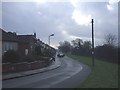
Llanrumney High School, from Ball Rd, Cardiff
Image: © John Lord
Taken: 16 Jan 2010
0.15 miles
4
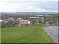
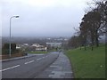
Llanrumney High School
In the middle distance is Pentwyn; the hills on the skyline range from Coed Wenallt (left/west) to Craig Llanishen (right/east)
Image: © John Thorn
Taken: 12 Apr 2006
0.18 miles