IMAGES TAKEN NEAR TO
Fremington Place, CARDIFF, CF3 4EG
Introduction
This page details the photographs taken nearby to Fremington Place, CF3 4EG by members of the Geograph project.
The Geograph project started in 2005 with the aim of publishing, organising and preserving representative images for every square kilometre of Great Britain, Ireland and the Isle of Man.

There are currently over 7.5m images from over14,400 individuals and you can help contribute to the project by visiting https://www.geograph.org.uk
Image Map
Images are licensed for reuse under creativecommons.org/licenses/by-sa/2.0
Notes
- Clicking on the map will re-center to the selected point.
- The higher the marker number, the further away the image location is from the centre of the postcode.
Image Listing (34 Images Found)
Images are licensed for reuse under creativecommons.org/licenses/by-sa/2.0
Image
Details
Distance
1
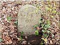
Old Boundary Marker on the B4487 Newport Road in Rumney
Municipal Boundary Marker among trees on the southeast side of the B4487 Newport Road. Rumney community. In 1938 the Monmouthshire parish of Rumney was incorporated into the city and county borough of Cardiff.
Milestone Society National ID: MON_RUMNEY01pb
Image: © R Guy
Taken: 15 Mar 2022
0.04 miles
2
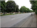
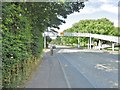
Tree-lined Newport Road, Rumney, Cardiff
The B4487 Newport Road in the Rumney area of Cardiff near the edge of the Llanrumney area of Cardiff.
Image: © Jaggery
Taken: 4 Jul 2017
0.05 miles
3
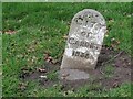
Old Boundary Marker on the B4487 Newport Road on Llanrumney
Municipal Boundary Marker on the northwest side of the B4487 Newport Road. Llanrumney Community. Inscribed CITY / OF / CARDIFF / 1938. In 1938 the Monmouthshire parish of Rumney was incorporated into the city and county borough of Cardiff.
Milestone Society National ID: MON_NPCF08Ba
Image: © R Guy
Taken: 29 May 2021
0.06 miles
4
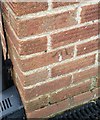
Ordnance Survey Cut Mark
This OS cut mark can be found on No20 Ilfracombe Crescent. It marks a point 56.678m above mean sea level.
Image: © Adrian Dust
Taken: 30 Dec 2018
0.08 miles
5
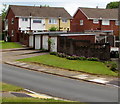
Witla Court Road houses and lockup garages, Rumney, Cardiff
Along Witla Court Road towards Marchwood Close.
Image: © Jaggery
Taken: 4 Jul 2017
0.09 miles
6
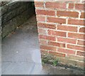
Ordnance Survey Cut Mark
This OS cut mark can be found on No183 Llanrumney Avenue. It marks a point 42.069m above mean sea level.
Image: © Adrian Dust
Taken: 29 Dec 2021
0.11 miles
7
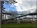
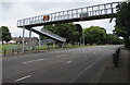
Footbridge
Footbridge over the B4487 in Llanrumney.
Image: © Alan Hughes
Taken: 17 Jan 2018
0.12 miles
8
Llanrumney, footbridge
Across B4487 (Newport Road).
Image: © Mike Faherty
Taken: 12 Jul 2016
0.12 miles
9
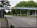
Northeast side of a Newport Road footbridge, Rumney, Cardiff
A warning sign on the footbridge shows 17' 0" headroom.
Image: © Jaggery
Taken: 4 Jul 2017
0.12 miles
10
Southwest side of a Newport Road footbridge, Rumney, Cardiff
A warning sign on the footbridge shows 17' 0" headroom.
Image: © Jaggery
Taken: 4 Jul 2017
0.12 miles