IMAGES TAKEN NEAR TO
Llangynwyd, MAESTEG, CF34 9RY
Introduction
This page details the photographs taken nearby to CF34 9RY by members of the Geograph project.
The Geograph project started in 2005 with the aim of publishing, organising and preserving representative images for every square kilometre of Great Britain, Ireland and the Isle of Man.

There are currently over 7.5m images from over14,400 individuals and you can help contribute to the project by visiting https://www.geograph.org.uk
Image Map
Images are licensed for reuse under creativecommons.org/licenses/by-sa/2.0
Notes
- Clicking on the map will re-center to the selected point.
- The higher the marker number, the further away the image location is from the centre of the postcode.
Image Listing (2 Images Found)
Images are licensed for reuse under creativecommons.org/licenses/by-sa/2.0
Image
Details
Distance
1

Power line next to track to Bryn Cynan Farm
Pylon and grid lines as they drop towards the Llynfi Valley.
Image: © Colin Pyle
Taken: 22 Aug 2008
0.21 miles
2
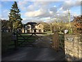
Orchard House
The Orchards near Llangynwyd.
Image: © Alan Hughes
Taken: 3 Jan 2017
0.24 miles