IMAGES TAKEN NEAR TO
Llangynwyd, MAESTEG, CF34 9RT
Introduction
This page details the photographs taken nearby to CF34 9RT by members of the Geograph project.
The Geograph project started in 2005 with the aim of publishing, organising and preserving representative images for every square kilometre of Great Britain, Ireland and the Isle of Man.

There are currently over 7.5m images from over14,400 individuals and you can help contribute to the project by visiting https://www.geograph.org.uk
Image Map
Images are licensed for reuse under creativecommons.org/licenses/by-sa/2.0
Notes
- Clicking on the map will re-center to the selected point.
- The higher the marker number, the further away the image location is from the centre of the postcode.
Image Listing (8 Images Found)
Images are licensed for reuse under creativecommons.org/licenses/by-sa/2.0
Image
Details
Distance
1

Orchard House
The Orchards near Llangynwyd.
Image: © Alan Hughes
Taken: 3 Jan 2017
0.05 miles
2
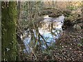
Nant y Gadlys Bridge
Nant y Gadlys Bridge, widened by the County Council in 1932.
Image: © Alan Hughes
Taken: 3 Jan 2017
0.12 miles
3
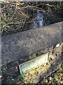
Ordnance Survey Cut Mark
This OS cut mark can be found on the west parapet of Nant-y-Gadlys Bridge. It marks a point 90.770m above mean sea level.
Image: © Adrian Dust
Taken: 7 Mar 2021
0.12 miles
5
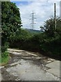
Pylon and junction of land and entrance to Bryn Cynan Farm
Pylon seen at a point where the lines drop towards the Georgia Pacific Paper Mills.
Image: © Colin Pyle
Taken: 22 Aug 2008
0.16 miles
6
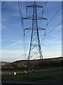
Electricity Pylon
Electricity pylon carrying power lines past Bryn Cynan and Bryn-y-Fro.
Image: © Alan Hughes
Taken: 3 Jan 2017
0.16 miles
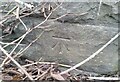
7
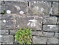
Ordnance Survey Cut Mark
This OS cut mark can be found on the wall east side of the A4063. It marks a point 96.683m above mean sea level.
Image: © Adrian Dust
Taken: 7 Mar 2021
0.18 miles
8

Power line next to track to Bryn Cynan Farm
Pylon and grid lines as they drop towards the Llynfi Valley.
Image: © Colin Pyle
Taken: 22 Aug 2008
0.22 miles