IMAGES TAKEN NEAR TO
Llangynwyd, MAESTEG, CF34 9RN
Introduction
This page details the photographs taken nearby to CF34 9RN by members of the Geograph project.
The Geograph project started in 2005 with the aim of publishing, organising and preserving representative images for every square kilometre of Great Britain, Ireland and the Isle of Man.

There are currently over 7.5m images from over14,400 individuals and you can help contribute to the project by visiting https://www.geograph.org.uk
Image Map
Images are licensed for reuse under creativecommons.org/licenses/by-sa/2.0
Notes
- Clicking on the map will re-center to the selected point.
- The higher the marker number, the further away the image location is from the centre of the postcode.
Image Listing (24 Images Found)
Images are licensed for reuse under creativecommons.org/licenses/by-sa/2.0
Image
Details
Distance
1
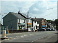
Pont Rhyd-y-cyff Shops
Near the north side of the square
Image: © Chris Shaw
Taken: Unknown
0.05 miles
2
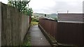
Footpath between Heol Tyn-y-Waun and Heol-yr-Ysgol 2019-7-20
Image: © Terrence Morgan
Taken: 20 Jul 2019
0.15 miles
6

Footpath between Heol Tyn-y-Waun and Heol-yr-Ysgol 2019-7-20
Image: © Terrence Morgan
Taken: 20 Jul 2019
0.16 miles
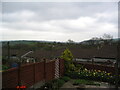
7
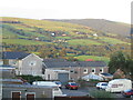
Llangynwyd looking South West
April 2004
Image: © Terrence Morgan
Taken: 10 Apr 2004
0.18 miles
9
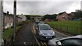
Llangynwyd looking South East
April 2004
Image: © Terrence Morgan
Taken: 10 Apr 2004
0.18 miles