IMAGES TAKEN NEAR TO
Maesteg Road, MAESTEG, CF34 9LD
Introduction
This page details the photographs taken nearby to Maesteg Road, CF34 9LD by members of the Geograph project.
The Geograph project started in 2005 with the aim of publishing, organising and preserving representative images for every square kilometre of Great Britain, Ireland and the Isle of Man.

There are currently over 7.5m images from over14,400 individuals and you can help contribute to the project by visiting https://www.geograph.org.uk
Image Map (Loading...)


Getting Data...Please wait
Leaflet Map data © OpenStreetMap
Images are licensed for reuse under creativecommons.org/licenses/by-sa/2.0
Notes
- Clicking on the map will re-center to the selected point.
- The higher the marker number, the further away the image location is from the centre of the postcode.
Image Listing (31 Images Found)
Images are licensed for reuse under creativecommons.org/licenses/by-sa/2.0
Image
Details
Distance
1
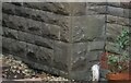
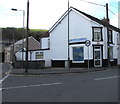
Ordnance Survey Cut Mark
This OS cut mark can be found on the NW face of the school on Maesteg Road. It marks a point 120.427m above mean sea level.
Image: © Adrian Dust
Taken: 7 Mar 2021
0.02 miles
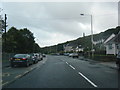
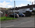
3

Overlooking Cwmfelin
Seen from close to the roundabout on the A4063. Mynydd Bach is in the background.
Image: © Andrew Hill
Taken: 21 Oct 2008
0.10 miles
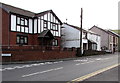
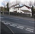
4
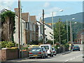
Pont Rhyd-y-Cyff
Houses on the Maesteg Road at the south of the square
Image: © Chris Shaw
Taken: Unknown
0.14 miles
5
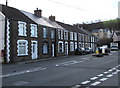
Row of houses, Mill Street, Garth
Alongside the B4282 Mill Street, viewed from the corner of Maiden Street.
Image: © Jaggery
Taken: 24 Feb 2017
0.16 miles
6
Vacant former Crown Stores on a Garth corner
On the corner of Maiden Street and Mill Street, viewed in February 2017.
Image: © Jaggery
Taken: 24 Feb 2017
0.18 miles
7
Mill Street houses west of Fairmeadows, Garth
The street name sign on the left is on the corner of Fairmeadows.
Image: © Jaggery
Taken: 27 Feb 2015
0.18 miles
8
Queen Elizabeth II postbox, Fairmeadows, Garth
Near the corner of the B4282 Mill Street.
Image: © Jaggery
Taken: 24 Feb 2017
0.19 miles
9
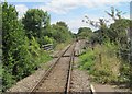
Troedyrhiw Garth railway station (site), Bridgend
Opened in 1864 on the Llynvi & Ogmore Railway's line from Pyle to Cymmer, this station closed in 1970. In 1992, the line was reopened to passengers between Bridgend and Maesteg, and a new station was opened for Garth around 100m north west of the old station.
View south east from the 1992 station, towards Llangwynydd and Bridgend.
Image: © Nigel Thompson
Taken: 16 Aug 2014
0.20 miles
10
Yr Hen Felin, Garth
Welsh for The Old Mill, Yr Hen Felin is on the north side of Mill Street, opposite Fairmeadows.
Image: © Jaggery
Taken: 24 Feb 2017
0.20 miles