1
Ordnance Survey Cut Mark
This OS cut mark can be found on the NW face of the school on Maesteg Road. It marks a point 120.427m above mean sea level.
Image: © Adrian Dust
Taken: 7 Mar 2021
0.09 miles
2
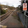
Troedyrhiw Garth railway station (site), Bridgend
Opened in 1864 on the Llynvi & Ogmore Railway's line from Pyle to Cymmer, this station closed in 1970. In 1992, the line was reopened to passengers between Bridgend and Maesteg, and a new station was opened for Garth around 100m north west of the old station.
View south east from the 1992 station, towards Llangwynydd and Bridgend.
Image: © Nigel Thompson
Taken: 16 Aug 2014
0.11 miles
3
Overlooking Cwmfelin
Seen from close to the roundabout on the A4063. Mynydd Bach is in the background.
Image: © Andrew Hill
Taken: 21 Oct 2008
0.11 miles
4
Queen Elizabeth II postbox, Fairmeadows, Garth
Near the corner of the B4282 Mill Street.
Image: © Jaggery
Taken: 24 Feb 2017
0.12 miles
5
Railway from Garth towards Tondu
Viewed from Garth station http://www.geograph.org.uk/photo/4380958 looking SE along the single track Maesteg Line which crosses a bridge http://www.geograph.org.uk/photo/4367797 over Mill Street behind the small yellow milepost showing 7 (miles to Bridgend).
Image: © Jaggery
Taken: 27 Feb 2015
0.13 miles
6
Pont Rhyd-y-Cyff
Houses on the Maesteg Road at the south of the square
Image: © Chris Shaw
Taken: Unknown
0.13 miles
7
Glan yr Afon, Garth, Maesteg
Cul-de-sac on the southeast side of the B4282. Glan yr Afon
is Welsh for riverbank, in this case the south bank of the Afon Llynfi.
Image: © Jaggery
Taken: 17 Feb 2017
0.13 miles
8
Row of houses, Mill Street, Garth
Alongside the B4282 Mill Street, viewed from the corner of Maiden Street.
Image: © Jaggery
Taken: 24 Feb 2017
0.13 miles
9
Mill Street houses, Garth
Between the corner of Fairmeadows on the right and the main entrance to Garth railway station on the left.
Image: © Jaggery
Taken: 24 Feb 2017
0.14 miles
10
Mill Street houses west of Fairmeadows, Garth
The street name sign on the left is on the corner of Fairmeadows.
Image: © Jaggery
Taken: 27 Feb 2015
0.14 miles


