IMAGES TAKEN NEAR TO
Talbot Street, MAESTEG, CF34 9BL
Introduction
This page details the photographs taken nearby to Talbot Street, CF34 9BL by members of the Geograph project.
The Geograph project started in 2005 with the aim of publishing, organising and preserving representative images for every square kilometre of Great Britain, Ireland and the Isle of Man.

There are currently over 7.5m images from over14,400 individuals and you can help contribute to the project by visiting https://www.geograph.org.uk
Image Map
Images are licensed for reuse under creativecommons.org/licenses/by-sa/2.0
Notes
- Clicking on the map will re-center to the selected point.
- The higher the marker number, the further away the image location is from the centre of the postcode.
Image Listing (201 Images Found)
Images are licensed for reuse under creativecommons.org/licenses/by-sa/2.0
Image
Details
Distance
1
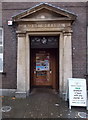
King George VI monogram at the entrance to Maesteg Post Office
The monogram shows that the building http://www.geograph.org.uk/photo/2955739 dates from 1938.
Image: © Jaggery
Taken: 30 Oct 2014
0.01 miles
2
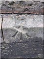
Ordnance Survey Rivet
This OS rivet can be found on the NW face of St David's Church. It marks a point 129.888m above mean sea level.
Image: © Adrian Dust
Taken: 9 Mar 2016
0.01 miles
3
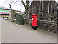
Queen Elizabeth II pillarbox and a telecoms cabinet, Talbot Street, Maesteg
Located near Maesteg Post Office. http://www.geograph.org.uk/photo/2955739
Image: © Jaggery
Taken: 24 Feb 2017
0.01 miles
4
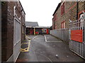
Royal Mail Delivery Office, Maesteg
Set back from Talbot Street.
Image: © Jaggery
Taken: 30 Oct 2014
0.01 miles
5
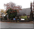
St David's Church, Maesteg
This is the north (Castle Street) side of the church on the corner of Talbot Street.
St David's is part of the Church in Wales Parish of Llangynwyd & Maesteg in the Diocese of Llandaff.
Image: © Jaggery
Taken: 30 Oct 2014
0.01 miles
6
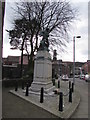
Maesteg War Memorial
The base is built of white flecked granite. On top is a bronze sculpture of two infantrymen, one advancing with bayonet fixed, stepping over his fallen comrade. Erected to commemorate Maesteg's dead of the Great War (First World War), the inscription was extended after the Second World War, with another inscription added after the Falklands War (1982). The War Memorial was Grade II listed in 1997.
Image: © Jaggery
Taken: 24 Feb 2017
0.01 miles
7
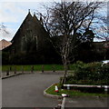
East side of St David's Church, Maesteg
Part of the Church in Wales Parish of Llangynwyd & Maesteg in the Diocese of Llandaff, the church is on the corner of Castle Street and Talbot Street. It was built in 1852-1853 as a Chapel of Ease for Llangynwyd Parish Church, to provide a more convenient Anglican service for the growing community of Maesteg. The building was Grade II listed in 1997.
Image: © Jaggery
Taken: 24 Feb 2017
0.02 miles
8
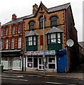
USA Fried Chicken in Maesteg
Town centre takeaway (chicken, burgers, ribs etc) at 25 Talbot Street.
Image: © Jaggery
Taken: 30 Oct 2014
0.02 miles
9
Talbot Street Dental Surgery, Maesteg
At 24 Talbot Street in the town centre, next door to USA Fried Chicken takeaway.
Image: © Jaggery
Taken: 24 Feb 2017
0.02 miles
10
Talbot Restaurant & Takeaway, Church Street, Maesteg
Near Maesteg Bus Station.
Image: © Jaggery
Taken: 24 Feb 2017
0.02 miles