IMAGES TAKEN NEAR TO
Protheroe Street, MAESTEG, CF34 0YN
Introduction
This page details the photographs taken nearby to Protheroe Street, CF34 0YN by members of the Geograph project.
The Geograph project started in 2005 with the aim of publishing, organising and preserving representative images for every square kilometre of Great Britain, Ireland and the Isle of Man.

There are currently over 7.5m images from over14,400 individuals and you can help contribute to the project by visiting https://www.geograph.org.uk
Image Map
Images are licensed for reuse under creativecommons.org/licenses/by-sa/2.0
Notes
- Clicking on the map will re-center to the selected point.
- The higher the marker number, the further away the image location is from the centre of the postcode.
Image Listing (89 Images Found)
Images are licensed for reuse under creativecommons.org/licenses/by-sa/2.0
Image
Details
Distance
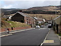
1
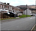
Adjacent Protheroe Street houses numbered 25 and 11, Caerau
House numbers in the row on the left are from 32 to 25 (away from the camera).
House numbers in the row in the distance are from 11 to 24, which means that
number 25 is next to number 11, whereas number 24 is about 80 metres away.
Must be confusing and annoying for posties and other delivery people new to the area!
Image: © Jaggery
Taken: 27 Feb 2015
0.01 miles
2
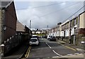
Protheroe Street, Caerau
The SE end of Protheroe Street, viewed across Cymmer Road.
Image: © Jaggery
Taken: 27 Feb 2015
0.02 miles
3

Change of road surface, Cymmer Road, Caerau
Looking north from the corner of Victoria Street.
Image: © Jaggery
Taken: 27 Feb 2015
0.03 miles
4
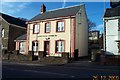
Caerau
The old police station at Caerau.
Image: © Richard Knights
Taken: 26 Dec 2000
0.04 miles
6
Down Church Street, Caerau
Church Street descends towards Cymmer Road.
Image: © Jaggery
Taken: 27 Feb 2015
0.05 miles
7
King George VI postbox, George Street, Caerau
In the wall here. http://www.geograph.org.uk/photo/4376694
Image: © Jaggery
Taken: 27 Feb 2015
0.05 miles
8
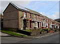
Church Street houses, Caerau
Viewed looking towards Cymmer Road.
Image: © Jaggery
Taken: 27 Feb 2015
0.05 miles
9

Ordnance Survey Cut Mark
This OS cut mark can be found at the junction of Cymer Road & George Street. It marks a point 213.689m above mean sea level.
Image: © Adrian Dust
Taken: 24 Nov 2020
0.05 miles
10

Shuttered corner shop in Caerau
M & V Stores on the corner of Cymmer Road and Victoria Street is closed at 1pm on a Friday.
Perhaps closed for lunch, or maybe closed down...
Image: © Jaggery
Taken: 27 Feb 2015
0.05 miles