IMAGES TAKEN NEAR TO
Lon-y-Parc, MAESTEG, CF34 0YE
Introduction
This page details the photographs taken nearby to Lon-y-Parc, CF34 0YE by members of the Geograph project.
The Geograph project started in 2005 with the aim of publishing, organising and preserving representative images for every square kilometre of Great Britain, Ireland and the Isle of Man.

There are currently over 7.5m images from over14,400 individuals and you can help contribute to the project by visiting https://www.geograph.org.uk
Image Map
Images are licensed for reuse under creativecommons.org/licenses/by-sa/2.0
Notes
- Clicking on the map will re-center to the selected point.
- The higher the marker number, the further away the image location is from the centre of the postcode.
Image Listing (24 Images Found)
Images are licensed for reuse under creativecommons.org/licenses/by-sa/2.0
Image
Details
Distance
1
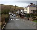
Griffiths Terrace, Caerau
Viewed from the corner of Church Street, looking past speed bumps.
Image: © Jaggery
Taken: 27 Feb 2015
0.07 miles
2
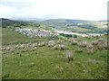
View to Brynheulog
The housing estate sits on the hillside and catches some sunshine.
Image: © Jeremy Bolwell
Taken: 16 Aug 2011
0.09 miles
3
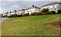
Rathbone Terrace houses, Caerau
Set above Protheroe Street.
Image: © Jaggery
Taken: 27 Feb 2015
0.09 miles
4
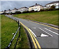
Speed bumps and railings in Caerau
Protheroe Street ascends towards the Rathbone Terrace junction.
Image: © Jaggery
Taken: 27 Feb 2015
0.10 miles
5
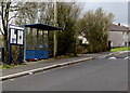
Church Street bus shelter and notice board, Caerau
Near the corner of Griffiths Terrace (ahead).
Image: © Jaggery
Taken: 27 Feb 2015
0.11 miles
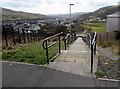
6
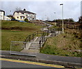
Long flight of steps in Caerau
Extending for 65 metres from Protheroe Street up to Church Street.
Image: © Jaggery
Taken: 27 Feb 2015
0.12 miles
7
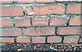
Ordnance Survey Cut Mark
This OS cut mark can be found on the wall NE side of Church Road. It marks a point 227.454m above mean sea level.
Image: © Adrian Dust
Taken: 24 Nov 2020
0.12 miles
8
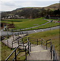
Zigzag steps, Caerau
The top half of these steps down from Church Street is straight.
The bottom half towards Protheroe Street uses a zigzag route.
Image: © Jaggery
Taken: 27 Feb 2015
0.12 miles
9
Down a long flight of steps in Caerau
The steps descend for 65 metres from Church Street to Protheroe Street.
Image: © Jaggery
Taken: 27 Feb 2015
0.12 miles
10
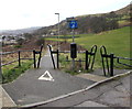
Inward sloping path barriers at the edge of Protheroe Street, Caerau
Preventing vehicular misuse of combined cycle routes and footpaths,
inward sloping metal barriers are wide enough for walkers and cyclists to pass through.
The label on the barrier on the left shows that it was manufactured by Fearn,
a trading division of Fearn (Truck Bodies) Limited.
Image: © Jaggery
Taken: 27 Feb 2015
0.13 miles