IMAGES TAKEN NEAR TO
Hermon Road, MAESTEG, CF34 0SQ
Introduction
This page details the photographs taken nearby to Hermon Road, CF34 0SQ by members of the Geograph project.
The Geograph project started in 2005 with the aim of publishing, organising and preserving representative images for every square kilometre of Great Britain, Ireland and the Isle of Man.

There are currently over 7.5m images from over14,400 individuals and you can help contribute to the project by visiting https://www.geograph.org.uk
Image Map
Images are licensed for reuse under creativecommons.org/licenses/by-sa/2.0
Notes
- Clicking on the map will re-center to the selected point.
- The higher the marker number, the further away the image location is from the centre of the postcode.
Image Listing (72 Images Found)
Images are licensed for reuse under creativecommons.org/licenses/by-sa/2.0
Image
Details
Distance
1
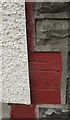
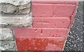
Ordnance Survey Cut Mark
This OS cut mark can be found on the front of No19A Hermon Road. It marks a point 177.485m above mean sea level.
Image: © Adrian Dust
Taken: 18 Jun 2016
0.01 miles
2
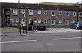
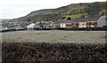
Glan yr Afon Court, Caerau
Located between Hermon Road and the east bank of a river, the Afon Llynfi. Glan yr Afon (Welsh for riverbank) is retirement/sheltered housing, managed by Wales & West Housing, containing 20 flats built in 1982.
Image: © Jaggery
Taken: 27 Feb 2015
0.02 miles
3
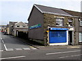
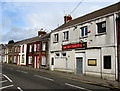
Caerau Chemist
The shop is at 68 Hermon Road, Caerau. The name Robert A. Davies is in smaller text alongside Caerau Chemist. NUMARK PHARMACIST is on the side wall.
Image: © Jaggery
Taken: 27 Feb 2015
0.02 miles
4
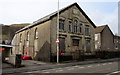
Former Bethany Presbyterian Chapel in Caerau
The building is on the west side of Hermon Road.
The year 1903 is inscribed on a tablet above the central window.
Image: © Jaggery
Taken: 27 Feb 2015
0.04 miles
5
Llynfi Coach House, Caerau
The pub at 76 Hermon Road was formerly the Royal British Legion Club.
Image: © Jaggery
Taken: 27 Feb 2015
0.05 miles
6
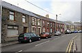
Houses on the west side of Hermon Street, Caerau
Looking north towards Crindau Square.
Image: © Jaggery
Taken: 27 Feb 2015
0.05 miles
7
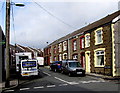
Gelli Street towards Grosvenor Terrace, Caerau
Grosvenor Terrace is behind the vehicles parked in Gelli Street.
Image: © Jaggery
Taken: 27 Feb 2015
0.05 miles
8
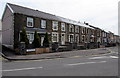
Northern end of Hermon Road, Caerau
The end house on the left is on the corner of Talana Terrace. http://www.geograph.org.uk/photo/4365347
Image: © Jaggery
Taken: 27 Feb 2015
0.06 miles
9
Site of the demolished Blaenllynfi Infant School in Caerau
Between Library Road and Grosvenor Terrace. The school buildings became redundant after Caerau Nursery School, Blaenllynfi Infant School and Blaencaerau Junior School amalgamated to form Caerau Primary School in September 2009. Caerau Primary School has occupied this http://www.geograph.org.uk/photo/4373550 purpose-built site since December 2009.
Image: © Jaggery
Taken: 27 Feb 2015
0.06 miles
10
Ordnance Survey Cut Mark
This OS cut mark can be found on No24 Dyffryn Road. It marks a point 185.443m above mean sea level.
Image: © Adrian Dust
Taken: 24 Nov 2020
0.07 miles