IMAGES TAKEN NEAR TO
Tonna Road, MAESTEG, CF34 0SB
Introduction
This page details the photographs taken nearby to Tonna Road, CF34 0SB by members of the Geograph project.
The Geograph project started in 2005 with the aim of publishing, organising and preserving representative images for every square kilometre of Great Britain, Ireland and the Isle of Man.

There are currently over 7.5m images from over14,400 individuals and you can help contribute to the project by visiting https://www.geograph.org.uk
Image Map
Images are licensed for reuse under creativecommons.org/licenses/by-sa/2.0
Notes
- Clicking on the map will re-center to the selected point.
- The higher the marker number, the further away the image location is from the centre of the postcode.
Image Listing (41 Images Found)
Images are licensed for reuse under creativecommons.org/licenses/by-sa/2.0
Image
Details
Distance
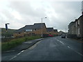
2
Housing near Caera
Row of council houses near Caerau, Maesteg. Perhaps not the architect's finest hour.
Image: © Alan Hughes
Taken: 29 Jul 2017
0.08 miles
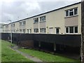
3

Houses on the north side of Magazine Street, Nantyffyllon
The name may be a use of the original meaning of magazine (a storehouse for merchandise, a warehouse or depot).
Image: © Jaggery
Taken: 27 Feb 2015
0.11 miles
4
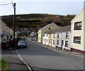
Bedw Street Caerau
Looking west along Bedw Street from the Coegnant Road end.
Image: © Jaggery
Taken: 27 Feb 2015
0.13 miles
5
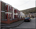
Magazine Street, Nantyffyllon
Houses on the south side of Magazine Street. The street name may be a use of the original meaning of magazine (a storehouse for merchandise, a warehouse or depot).
Image: © Jaggery
Taken: 27 Feb 2015
0.13 miles
6
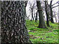
Woodlands in Dyffryn.
This picture was taken on Dyffryn Mountain, near Tonna Road.
Image: © Jamie Murphy
Taken: 4 Mar 2007
0.14 miles
7
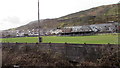
Football ground on the west bank of the Llynfi in Caerau
The home ground of Caerau football club. Association football was first played on an organised basis in Caerau in 1901. There have been several name changes in the following decades. Although the name on a nearby building shows Caerau Athletic, the Welsh League website at the late February 2015 date of this photo calls the club Caerau FC.
Image: © Jaggery
Taken: 27 Feb 2015
0.15 miles
8
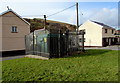
Bedw Street electricity substation, Caerau
Located on the corner of Bedw Street and Magazine Street, a few metres on the Caerau side of the Nantyffyllon boundary. The Western Power Distribution electricity substation identifier is BEDW STREET S/S 561054.
Image: © Jaggery
Taken: 27 Feb 2015
0.15 miles
9
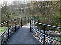
Footbridge over the River Llynfi, Spelter, Maesteg
The footbridge carries a path connecting Tonna Road on the western side of the river with Coegnant Road, Heol Tywith and the Spelter Industrial Estate on the eastern (camera) side.
Image: © Jaggery
Taken: 17 Nov 2011
0.15 miles
10
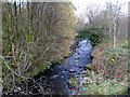
River Llynfi flows towards a footbridge, Maesteg
Viewed from this footbridge. http://www.geograph.org.uk/photo/2698717
The Llynfi is a tributary of the River Ogmore.
Image: © Jaggery
Taken: 17 Nov 2011
0.15 miles