IMAGES TAKEN NEAR TO
Pond Mawr, MAESTEG, CF34 0NG
Introduction
This page details the photographs taken nearby to Pond Mawr, CF34 0NG by members of the Geograph project.
The Geograph project started in 2005 with the aim of publishing, organising and preserving representative images for every square kilometre of Great Britain, Ireland and the Isle of Man.

There are currently over 7.5m images from over14,400 individuals and you can help contribute to the project by visiting https://www.geograph.org.uk
Image Map
Images are licensed for reuse under creativecommons.org/licenses/by-sa/2.0
Notes
- Clicking on the map will re-center to the selected point.
- The higher the marker number, the further away the image location is from the centre of the postcode.
Image Listing (49 Images Found)
Images are licensed for reuse under creativecommons.org/licenses/by-sa/2.0
Image
Details
Distance
1
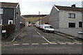
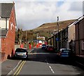
Pit Street, Garth, Maesteg
From the east side of the B4282 Bridgend Road, Pit Street leads to Pond Mawr.
Image: © Jaggery
Taken: 17 Feb 2017
0.02 miles
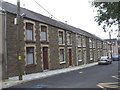
2
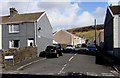
East along Pit Street, Garth, Maesteg
Viewed across the B4282 Bridgend Road. The street name sign shows that Pit Street leads to Pond Mawr.
Image: © Jaggery
Taken: 27 Feb 2015
0.03 miles
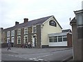
4
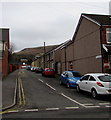
Mission Road, Garth, Maesteg
Dead-end road from Bridgend Road to Garth Primary School.
Image: © Jaggery
Taken: 17 Feb 2017
0.07 miles
5
Mission Road, Garth, Maesteg
Looking east from the Bridgend Road end towards the red entrance gates http://www.geograph.org.uk/photo/4364220 to Garth Primary School.
Image: © Jaggery
Taken: 27 Feb 2015
0.07 miles
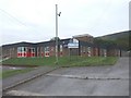
6
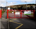
Red entrance gates to Garth Primary School, Maesteg
At the eastern end of Mission Road.
Image: © Jaggery
Taken: 27 Feb 2015
0.07 miles
9
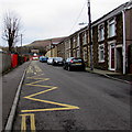
Zigzag markings on Mission Road, Garth, Maesteg
The yellow marking define the Keep Clear Zone (no stopping or parking) outside Garth Primary School.
Image: © Jaggery
Taken: 17 Feb 2017
0.09 miles
10
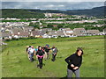
Llwybr Garth / Garth Footpath
Cerddwyr yn dilyn llwybr cyhoeddus uwchben pentre Garth.
Walkers following a public footpath above the village of Garth (trans. hill).
Image: © Alan Richards
Taken: 17 Jun 2012
0.10 miles