IMAGES TAKEN NEAR TO
Talgarth Street, MAESTEG, CF34 0LY
Introduction
This page details the photographs taken nearby to Talgarth Street, CF34 0LY by members of the Geograph project.
The Geograph project started in 2005 with the aim of publishing, organising and preserving representative images for every square kilometre of Great Britain, Ireland and the Isle of Man.

There are currently over 7.5m images from over14,400 individuals and you can help contribute to the project by visiting https://www.geograph.org.uk
Image Map
Images are licensed for reuse under creativecommons.org/licenses/by-sa/2.0
Notes
- Clicking on the map will re-center to the selected point.
- The higher the marker number, the further away the image location is from the centre of the postcode.
Image Listing (57 Images Found)
Images are licensed for reuse under creativecommons.org/licenses/by-sa/2.0
Image
Details
Distance
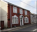
1
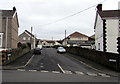
Talgarth Street, Maesteg
From Bridgend Road along Talgarth Street towards Turberville Street and Maesgwyn.
Image: © Jaggery
Taken: 17 Feb 2017
0.01 miles
2
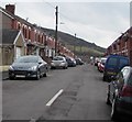
Turberville Street towards Maesgwyn, Maesteg
From the corner of Duke Street.
Image: © Jaggery
Taken: 17 Feb 2017
0.04 miles
4
Heol Faen, Garth, Maesteg
Viewed across Bridgend Road. Garth General Stores and Off Licence http://www.geograph.org.uk/photo/4364072 is on the left.
Image: © Jaggery
Taken: 27 Feb 2015
0.05 miles
5
The Oddfellows Rest, Garth, Maesteg
Former pub at 200 Bridgend Road, converted to flats.
Image: © Jaggery
Taken: 27 Feb 2015
0.05 miles
6
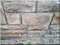
Ordnance Survey Cut Mark
This OS cut mark can be found on No84 Bridgend Road. It marks a point 109.460m above mean sea level.
Image: © Adrian Dust
Taken: 11 Nov 2020
0.05 miles
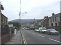
7
Heol Faen, Garth, Maesteg
Viewed across the B4282 Bridgend Road. A Premier convenience store and off licence http://www.geograph.org.uk/photo/5288653 is on the left.
Image: © Jaggery
Taken: 17 Feb 2017
0.05 miles
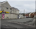
8
Garth General Stores, Maesteg
Premier convenience store and off licence on the corner of Bridgend Road and Heol Faen.
Image: © Jaggery
Taken: 27 Feb 2015
0.07 miles
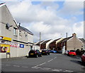
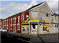
9
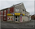
Garth Stores, Maesteg
Premier convenience store and off licence on the corner of Bridgend Road and Heol Faen, viewed in February 2017. Garth Stores was Garth General Stores in February 2015. http://www.geograph.org.uk/photo/4364072
Image: © Jaggery
Taken: 17 Feb 2017
0.07 miles
10
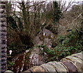
Nant y Twlc, Garth, Maesteg
The brook Nant y Twlc flows away from a Bridgend Road bridge.
Its confluence with the Afon Llynfi is about 70 metres ahead.
Image: © Jaggery
Taken: 17 Feb 2017
0.10 miles