IMAGES TAKEN NEAR TO
Barnardo Street, MAESTEG, CF34 0HT
Introduction
This page details the photographs taken nearby to Barnardo Street, CF34 0HT by members of the Geograph project.
The Geograph project started in 2005 with the aim of publishing, organising and preserving representative images for every square kilometre of Great Britain, Ireland and the Isle of Man.

There are currently over 7.5m images from over14,400 individuals and you can help contribute to the project by visiting https://www.geograph.org.uk
Image Map
Images are licensed for reuse under creativecommons.org/licenses/by-sa/2.0
Notes
- Clicking on the map will re-center to the selected point.
- The higher the marker number, the further away the image location is from the centre of the postcode.
Image Listing (46 Images Found)
Images are licensed for reuse under creativecommons.org/licenses/by-sa/2.0
Image
Details
Distance
1
Homfray Street, Nantyffyllon
A view east from the corner of the former Rock Hotel. http://www.geograph.org.uk/photo/3009979
Image: © Jaggery
Taken: 17 Nov 2011
0.05 miles
2
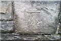
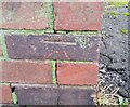
Ordnance Survey Cut Mark
This OS cut mark can be found on the wall of the Salem Chapel. It marks a point 164.406m above mean sea level.
Image: © Adrian Dust
Taken: 10 Nov 2020
0.06 miles
3
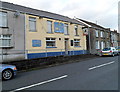
The General Picton, Nantyffyllon
Pub and 40-seat restaurant in Picton Place, viewed from the corner of Grove Street. http://www.geograph.org.uk/photo/3009792
Lieutenant General Sir Thomas Picton, the most senior officer to die at the Battle of Waterloo (June 1815), was born in Pembrokeshire, Wales, in 1758.
Image: © Jaggery
Taken: 17 Nov 2011
0.07 miles
4
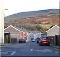
Northern side of Grove Street, Nantyffyllon
Viewed from Picton Street.
Image: © Jaggery
Taken: 17 Nov 2011
0.07 miles
5
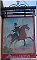
The General Picton pub sign, Nantyffyllon
This curious depiction of Lieutenant General Sir Thomas Picton is the pub sign here. http://www.geograph.org.uk/photo/3009802
With black top hat and tailcoat, he appears to be a Georgian gentleman out for a ride in the countryside, yet he is holding a sabre, there are troops behind him, and the scene looks like part of a battlefield.
Image: © Jaggery
Taken: 17 Nov 2011
0.07 miles
6
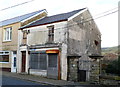
Derelict former Kool Kuts shop, Nantyffyllon
Located in Picton Street, next door to the former Salem chapel. http://www.geograph.org.uk/photo/3009910
Image: © Jaggery
Taken: 17 Nov 2011
0.07 miles
7
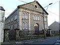
Grade II (Star) listed former Salem Baptist Chapel, Nantyffyllon
Located on the east side of Picton Street. The chapel, built in 1872 and
Grade II (Star) Listed in 1997, is now used as offices for the Welsh
Religious Buildings Trust.
Image: © Jaggery
Taken: 17 Nov 2011
0.07 miles
8
Ordnance Survey Cut Mark
This OS cut mark can be found on Nantyffyllan Sub-station, Bangor Street. It marks a point 151.946m above mean sea level.
Image: © Adrian Dust
Taken: 10 Nov 2020
0.09 miles
9

Former Rock Hotel, Nantyffyllon
Located on the corner of Picton Street and Homfray Street. Now a dwelling,
the building was formerly the Rock Hotel, dating from 1898.
Image: © Jaggery
Taken: 17 Nov 2011
0.09 miles
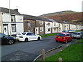
10

Nantyffyllon : Picton Street north of the former Salem chapel
The Grade II* listed former chapel http://www.geograph.org.uk/photo/3009910 is a few metres behind the camera.
Next door to the former Kool Kuts http://www.geograph.org.uk/photo/3009921 is Ceri's Salon, open for business.
Image: © Jaggery
Taken: 17 Nov 2011
0.09 miles