1
Ordnance Survey Cut Mark
This OS cut mark can be found on the east angle of St Peter's Church. It marks a point 174.583m above mean sea level.
Image: © Adrian Dust
Taken: 10 Nov 2020
0.04 miles
2
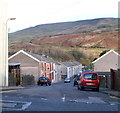
Nantyffyllon: Picton Street houses at the Nantyffyllon Terrace junction
Viewed across Picton Street (A4063)
Image: © Jaggery
Taken: 17 Nov 2011
0.04 miles
3
Bus shelter and bench, Picton Street, Nantyffyllon
Located near the Nantyffyllon Terrace junction. http://www.geograph.org.uk/photo/3010055
Image: © Jaggery
Taken: 17 Nov 2011
0.04 miles
4
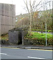
Neglected urinal, Picton Street, Nantyffyllon
Shown on some maps as PC (public convenience) this small concrete structure
is a very basic urinal (no pedestals or wash basin) which appears
not to have been cleaned in a very long time.
Located at the corner of Picton Street and Nantyffyllon Terrace.
Image: © Jaggery
Taken: 17 Nov 2011
0.04 miles
5
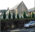
Former St Peter?s Church, Nantyffyllon
Set above the west side of Picton Street, the former church has been converted to residential use.
Image: © Jaggery
Taken: 17 Nov 2011
0.05 miles
6
Nantyffyllon : Picton Street north of the former Salem chapel
The Grade II* listed former chapel http://www.geograph.org.uk/photo/3009910 is a few metres behind the camera.
Next door to the former Kool Kuts http://www.geograph.org.uk/photo/3009921 is Ceri's Salon, open for business.
Image: © Jaggery
Taken: 17 Nov 2011
0.05 miles
7
Former Rock Hotel, Nantyffyllon
Located on the corner of Picton Street and Homfray Street. Now a dwelling,
the building was formerly the Rock Hotel, dating from 1898.
Image: © Jaggery
Taken: 17 Nov 2011
0.05 miles
8
Ordnance Survey Rivet
This OS rivet can be found on the window sill of No63 Picton Street. It marks a point 173.684m above mean sea level.
Image: © Adrian Dust
Taken: 10 Nov 2020
0.06 miles
9
Ordnance Survey Cut Mark
This OS cut mark can be found on the wall of the Salem Chapel. It marks a point 164.406m above mean sea level.
Image: © Adrian Dust
Taken: 10 Nov 2020
0.09 miles
10
Homfray Street, Nantyffyllon
A view east from the corner of the former Rock Hotel. http://www.geograph.org.uk/photo/3009979
Image: © Jaggery
Taken: 17 Nov 2011
0.10 miles


