IMAGES TAKEN NEAR TO
Nantyffyllon, MAESTEG, CF34 0HA
Introduction
This page details the photographs taken nearby to CF34 0HA by members of the Geograph project.
The Geograph project started in 2005 with the aim of publishing, organising and preserving representative images for every square kilometre of Great Britain, Ireland and the Isle of Man.

There are currently over 7.5m images from over14,400 individuals and you can help contribute to the project by visiting https://www.geograph.org.uk
Image Map
Images are licensed for reuse under creativecommons.org/licenses/by-sa/2.0
Notes
- Clicking on the map will re-center to the selected point.
- The higher the marker number, the further away the image location is from the centre of the postcode.
Image Listing (20 Images Found)
Images are licensed for reuse under creativecommons.org/licenses/by-sa/2.0
Image
Details
Distance
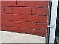
1
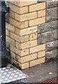
Ordnance Survey Cut Mark
This OS cut mark can be found on the west angle of the school. It marks a point 166.322m above mean sea level.
Image: © Adrian Dust
Taken: 10 Nov 2020
0.16 miles
2
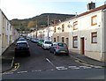
John Street, Nantyffyllon
Viewed from the High Street end looking towards Uplands Drive.
Image: © Jaggery
Taken: 17 Nov 2011
0.16 miles
3
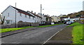
Duffryn Madog, Nantyffyllon
The residential road Duffryn Madog climbs away from the Masons Arms http://www.geograph.org.uk/photo/3007783 corner.
Image: © Jaggery
Taken: 17 Nov 2011
0.17 miles
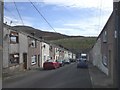
5
Ordnance Survey Cut Mark
This OS cut mark can be found on No32 Garnwen Road. It marks a point 174.437m above mean sea level.
Image: © Adrian Dust
Taken: 10 Nov 2020
0.19 miles
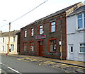
6

Former Siloh Chapel, High Street, Nantyffyllon
Inscriptions circling and below the round window show that the building
was erected in 1876 as Siloh Independent Chapel. Now converted to flats.
Image: © Jaggery
Taken: 17 Nov 2011
0.20 miles
7
Elderbush Inn, Nantyffyllon
There is no pub sign on the wall of this High Street pub, only a name board above the doorway.
Image: © Jaggery
Taken: 17 Nov 2011
0.20 miles
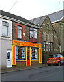
8
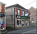
Nantyffyllon post office
Post office and shop at 1 Picton Street, on the corner of Coronation Terrace.
Image: © Jaggery
Taken: 17 Nov 2011
0.20 miles
9
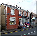
Former High Street butchers' shop, Nantyffyllon
Part dwelling and part shop, number 45 High Street is next door to the post office. http://www.geograph.org.uk/photo/300983
The butchers' shop closed several years ago. There is a row of children's clothes and other children's items on display outside the premises.
Image: © Jaggery
Taken: 17 Nov 2011
0.20 miles
10
Phoenix Motors Factors, Nantyffyllon
The Picton Street business is a motoring parts and accessories store,
and a camping & caravanning centre.
Image: © Jaggery
Taken: 17 Nov 2011
0.20 miles