IMAGES TAKEN NEAR TO
Pyle Inn Way, BRIDGEND, CF33 6LP
Introduction
This page details the photographs taken nearby to Pyle Inn Way, CF33 6LP by members of the Geograph project.
The Geograph project started in 2005 with the aim of publishing, organising and preserving representative images for every square kilometre of Great Britain, Ireland and the Isle of Man.

There are currently over 7.5m images from over14,400 individuals and you can help contribute to the project by visiting https://www.geograph.org.uk
Image Map
Images are licensed for reuse under creativecommons.org/licenses/by-sa/2.0
Notes
- Clicking on the map will re-center to the selected point.
- The higher the marker number, the further away the image location is from the centre of the postcode.
Image Listing (65 Images Found)
Images are licensed for reuse under creativecommons.org/licenses/by-sa/2.0
Image
Details
Distance
1
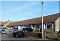
Row of bungalows, Pyle Inn Way, Pyle
This is one of two adjacent rows of bungalows on the east side of Pyle Inn Road.
Image: © Jaggery
Taken: 29 Nov 2012
0.05 miles
2
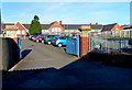
Entrance to Pil Primary School, Pyle
Viewed from a lane on the east side of Pyle Inn Way. The school uses the Welsh name for Pyle.
Image: © Jaggery
Taken: 29 Nov 2012
0.06 miles
3
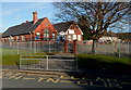
Pil Primary School, Pyle
This is the western side of the school, viewed from Pyle Inn Way. The school name is the Welsh for Pyle.
Image: © Jaggery
Taken: 29 Nov 2012
0.07 miles
4
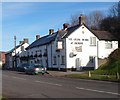
Pyle, Ye Olde Wine House
Public house and restaurant on Pyle Road; back bar, serving two rooms: left, eating, right, drinking. Exposed stonework, open fires, wooden beams; no cask ales.
Image: © Mike Faherty
Taken: 14 Jul 2016
0.07 miles
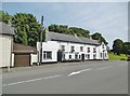
5
Ye Olde Wine House, Pyle
Viewed across Pyle Road (the A48). Also known as The Tap, this former coaching inn dating from the late 17th century has had other names at various times, including The Inn at Pyle, The White Hart and The Old House.
Image: © Jaggery
Taken: 29 Nov 2012
0.07 miles
6
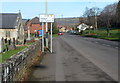
Pyle Road, Pyle
A view north along Pyle Road (the A48), 4 miles from Margam and 6 from Port Talbot.
The Church of St James http://www.geograph.org.uk/photo/3244151 is on the left.
Image: © Jaggery
Taken: 29 Nov 2012
0.08 miles
7
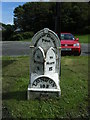
Milepost, Pyle.
One of a series of cast-iron mileposts in parishes along the old Cardiff to Swansea road.
Image: © Colin Pyle
Taken: 1 Sep 2009
0.08 miles
9
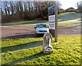
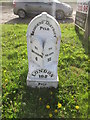
Milestone alongside Pyle Road, Pyle
Located between Pyle Road (the A48) and Ye Olde Wine House http://www.geograph.org.uk/photo/3244162 's car park.
Distances shown are London 183 (miles), Bridgend 6, Neath 12.
Image: © Jaggery
Taken: 29 Nov 2012
0.09 miles
10
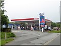
Esso filling station and Costa coffee shop, Pyle
Formerly run by Texaco Image
Image: © David Smith
Taken: 1 Jun 2018
0.09 miles