1
Ordnance Survey Cut Mark
This OS cut mark can be found on a concrete post SE side of Pont George Road. It marks a point 43.111m above mean sea level.
Image: © Adrian Dust
Taken: 18 Aug 2021
0.07 miles
2
Corner of Pyle Road and Monk Road, Pyle
Viewed across Pyle Road (the A48). The corner building is Llys Cynffig, housing with the support of resident management staff. There are 30 1-bedroom flats, built in 1985.
Image: © Jaggery
Taken: 29 Nov 2012
0.12 miles
3
Ordnance Survey Cut Mark
This OS cut mark can be found on the north face of the railway bridge. It marks a point 35.150m above mean sea level.
Image: © Adrian Dust
Taken: 10 Nov 2017
0.13 miles
4
Bus shelter on A48 in Pyle
The stop serves houses on the northern edge of Pyle
Image: © David Smith
Taken: 1 Jun 2018
0.13 miles
5
Pyle Road railway bridge, Pyle
The bridge carries a single-track freight-only railway over Pyle Road (the A48).
Image: © Jaggery
Taken: 29 Nov 2012
0.13 miles
6
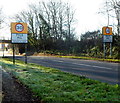
Northern boundary of Pyle
The A48 from Margam reaches Pyle, a large village in Bridgend county borough.
Image: © Jaggery
Taken: 29 Nov 2012
0.14 miles
7
Milepost, Pyle.
One of a series of cast-iron mileposts in parishes along the old Cardiff to Swansea road.
Image: © Colin Pyle
Taken: 1 Sep 2009
0.14 miles
8
Old Milepost by the A48, Margam Road, Pyle
Glamorgan Gothic by the A48, in parish of Pyle (Bridgend County Borough District), Margam Road, Pyle, 100m North of Ye Olde Wine House on deep verge.
Inscription reads:-
: TO / BRIDGEND / 6 : : BRIDGEND DISTRICT / PYLE : : LONDON / 183 / PYLE / PARISH : : TO / NEATH / 12 :
Grade II listed by Cadw. Reference Number: 19180
https://cadwpublic-api.azurewebsites.net/reports/listedbuilding/FullReport?lang=&id=19180
Surveyed
Milestone Society National ID: GLA_183BENT06.
Image: © Milestone Society
Taken: Unknown
0.15 miles
9
Milestone alongside Pyle Road, Pyle
Located between Pyle Road (the A48) and Ye Olde Wine House http://www.geograph.org.uk/photo/3244162 's car park.
Distances shown are London 183 (miles), Bridgend 6, Neath 12.
Image: © Jaggery
Taken: 29 Nov 2012
0.15 miles
10
Ordnance Survey Cut Mark
This OS cut mark can be found on the east parapet of Pyle Bridge. It marks a point 32.464m above mean sea level.
Image: © Adrian Dust
Taken: 7 Jun 2020
0.15 miles


