IMAGES TAKEN NEAR TO
Ffordd Y Chwarel, BRIDGEND, CF33 6FA
Introduction
This page details the photographs taken nearby to Ffordd Y Chwarel, CF33 6FA by members of the Geograph project.
The Geograph project started in 2005 with the aim of publishing, organising and preserving representative images for every square kilometre of Great Britain, Ireland and the Isle of Man.

There are currently over 7.5m images from over14,400 individuals and you can help contribute to the project by visiting https://www.geograph.org.uk
Image Map
Images are licensed for reuse under creativecommons.org/licenses/by-sa/2.0
Notes
- Clicking on the map will re-center to the selected point.
- The higher the marker number, the further away the image location is from the centre of the postcode.
Image Listing (50 Images Found)
Images are licensed for reuse under creativecommons.org/licenses/by-sa/2.0
Image
Details
Distance
1
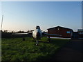
Hawker Hunter
This Hawker Hunter is in the grounds of 2117 (Kenfig Hill) Squadron, Air Training Corps
Image: © John Finch
Taken: 10 Nov 2011
0.03 miles
2
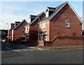
Four modern houses on the south side of Prince Road, Kenfig Hill
Viewed from the edge of Y Brynddu pub. http://www.geograph.org.uk/photo/3262789 The houses were built c2007.
Image: © Jaggery
Taken: 29 Nov 2012
0.09 miles
3
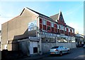
Kenfig Hill Labour Club & Institute
Viewed across Prince Road from the edge of the post office. http://www.geograph.org.uk/photo/3262764
Image: © Jaggery
Taken: 29 Nov 2012
0.11 miles
4
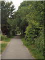
Cycle track on National Cycle Route 4, Kenfig Hill
National Cycle Route 4 passes along both a cycle track and stretches of road at Kenfig Hill. It’s seen here part way along the off-road track, which is approximately 600 metres long. This well-wooded track runs along part of the route once taken by the Dyffryn Llynfi & Porthcawl Railway.
Image: © eswales
Taken: 15 Jun 2022
0.11 miles
5
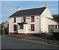
Y Brynddu pub, Kenfig Hill
This pub at 26 Prince Road must be a candidate for least conspicuous pub in Wales, if not in the whole of the UK. There is no pub sign, only a discreet name sign on the wall between two upstairs windows.
The temporary presence of a small keg on the right is the only other clue that this is a pub.
Image: © Jaggery
Taken: 29 Nov 2012
0.11 miles
6
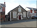
Talbot Community Centre, Kenfig Hill
Located in Prince Road near the B4281, the community centre is exactly that - owned and run by the local community, for the local community. Most of the people involved are volunteers.
The name above the door, Talbot Institute, is a reminder of the building's earlier history. Given to Kenfig Hill by the Talbot family in 1911, the building was in use as Talbot Miners' Welfare Institute until closure of the last local colliery in 1959.
Image: © Jaggery
Taken: 29 Nov 2012
0.12 miles
7
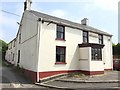
Y Brynddu, Kenfig Hill
Has time finally been called at Y Brynddu?
Image: © Alan Hughes
Taken: 7 Jun 2016
0.12 miles
8
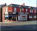
J & A Antiques, Kenfig Hill
The business is at 1 Prince Road, on the corner of Commercial Street, facing the War Memorial. http://www.geograph.org.uk/photo/3262756
Image: © Jaggery
Taken: 29 Nov 2012
0.12 miles
9
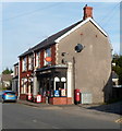
Kenfig Hill post office and store
Located near the southern end of Prince Road, about 50 metres from the B4281 junction.
Image: © Jaggery
Taken: 29 Nov 2012
0.12 miles
10
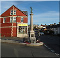
Kenfig Hill War Memorial
The War Memorial is located at the southern of Prince Road alongside the B4281 (Commercial Street and Moriah Place).
Image: © Jaggery
Taken: 29 Nov 2012
0.13 miles