IMAGES TAKEN NEAR TO
Kenfig Hill, BRIDGEND, CF33 6DS
Introduction
This page details the photographs taken nearby to CF33 6DS by members of the Geograph project.
The Geograph project started in 2005 with the aim of publishing, organising and preserving representative images for every square kilometre of Great Britain, Ireland and the Isle of Man.

There are currently over 7.5m images from over14,400 individuals and you can help contribute to the project by visiting https://www.geograph.org.uk
Image Map
Images are licensed for reuse under creativecommons.org/licenses/by-sa/2.0
Notes
- Clicking on the map will re-center to the selected point.
- The higher the marker number, the further away the image location is from the centre of the postcode.
Image Listing (8 Images Found)
Images are licensed for reuse under creativecommons.org/licenses/by-sa/2.0
Image
Details
Distance
1
Pen y castell
Looking up to the hill summit from the B4281 at Kenfig Hill. The triangulation point is visible, (although slightly obscured by a bush) to the left of the rightmost tree.
Image: © Chris Shaw
Taken: Unknown
0.08 miles
2
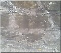
Ordnance Survey Cut Mark
This OS cut mark can be found on the wall south side of the road. It marks a point 117.072m above mean sea level.
Image: © Adrian Dust
Taken: 3 Sep 2021
0.13 miles
3
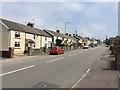
Kenfig Hill
The hill / main road at Kenfig Hill.
Image: © Alan Hughes
Taken: 7 Jun 2016
0.14 miles
4
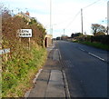
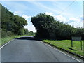
Western boundary of Cefn Cribwr
The B4281 from Kenfig Hill reaches Cefn Cribwr, a village and community in Bridgend County Borough.
Image: © Jaggery
Taken: 29 Nov 2012
0.16 miles
5
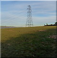
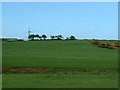
Electricity pylon at the western edge of Cefn Cribwr
Viewed from the B4281 at the eastern edge of Kenfig Hill.
Image: © Jaggery
Taken: 29 Nov 2012
0.18 miles
6
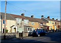
Houses in the east of Kenfig Hill
The houses are on the north side of the B4281 in the east of Kenfig Hill,
on the approach to the western boundary of Cefn Cribwr.
Image: © Jaggery
Taken: 29 Nov 2012
0.20 miles
7
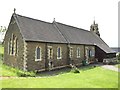
St.Theodore's Church, Kenfig Hill
St.Theodore's Church from the northeast.
Image: © Alan Hughes
Taken: 7 Jun 2016
0.25 miles