IMAGES TAKEN NEAR TO
Commercial Street, BRIDGEND, CF33 6DN
Introduction
This page details the photographs taken nearby to Commercial Street, CF33 6DN by members of the Geograph project.
The Geograph project started in 2005 with the aim of publishing, organising and preserving representative images for every square kilometre of Great Britain, Ireland and the Isle of Man.

There are currently over 7.5m images from over14,400 individuals and you can help contribute to the project by visiting https://www.geograph.org.uk
Image Map (Loading...)


Getting Data...Please wait
Leaflet Map data © OpenStreetMap
Images are licensed for reuse under creativecommons.org/licenses/by-sa/2.0
Notes
- Clicking on the map will re-center to the selected point.
- The higher the marker number, the further away the image location is from the centre of the postcode.
Image Listing (41 Images Found)
Images are licensed for reuse under creativecommons.org/licenses/by-sa/2.0
Image
Details
Distance
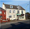
1

Gorgeous Grooming, Kenfig Hill
Dog grooming premises at 1 Commercial Street, opposite Prince Road.
Street name signs on the pavement show that the pink house is in Moriah Place.
Image: © Jaggery
Taken: 29 Nov 2012
0.05 miles
2
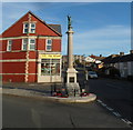
Kenfig Hill War Memorial
The War Memorial is located at the southern of Prince Road alongside the B4281 (Commercial Street and Moriah Place).
Image: © Jaggery
Taken: 29 Nov 2012
0.06 miles
3
The Spices Indian takeaway, Kenfig Hill
Indian cuisine takeaway located on the corner of Moriah Place and Prince Road, opposite the War Memorial. http://www.geograph.org.uk/photo/3262756 The premises have had other occupiers in recent years, including Panda House takeaway and Lee Kee Chinese takeaway.
Image: © Jaggery
Taken: 29 Nov 2012
0.07 miles
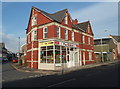
4
Moriah Business Centre, Kenfig Hill
The name board above the white door shows Moriah Business Centre.
Its location is on the north side of the B4281, here named Moriah Place.
Image: © Jaggery
Taken: 29 Nov 2012
0.07 miles
5
J & A Antiques, Kenfig Hill
The business is at 1 Prince Road, on the corner of Commercial Street, facing the War Memorial. http://www.geograph.org.uk/photo/3262756
Image: © Jaggery
Taken: 29 Nov 2012
0.07 miles
6
South & West Country Sports, Kenfig Hill
Metal bars protect the windows of this gunsmiths' and gun dealers' premises at 14 Moriah Place,
where the right side of the South & West Country Sports name board is missing.
Image: © Jaggery
Taken: 29 Nov 2012
0.08 miles
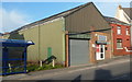
7
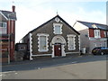
Talbot Community Centre, Kenfig Hill
Located in Prince Road near the B4281, the community centre is exactly that - owned and run by the local community, for the local community. Most of the people involved are volunteers.
The name above the door, Talbot Institute, is a reminder of the building's earlier history. Given to Kenfig Hill by the Talbot family in 1911, the building was in use as Talbot Miners' Welfare Institute until closure of the last local colliery in 1959.
Image: © Jaggery
Taken: 29 Nov 2012
0.08 miles
8
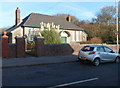
Kenfig Hill Clinic
The inscription in stone above the doorway of the Waunbant Road building is
CHILD WELFARE CLINIC
KENFIG HILL
1938.
Image: © Jaggery
Taken: 29 Nov 2012
0.09 miles
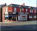
9

Sweetie-licious, Kenfig Hill
The shop at 27 Commercial Street sells sweets,
lollipops and other confectionery, soft drinks and ice cream.
Image: © Jaggery
Taken: 29 Nov 2012
0.09 miles
10
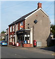
Kenfig Hill post office and store
Located near the southern end of Prince Road, about 50 metres from the B4281 junction.
Image: © Jaggery
Taken: 29 Nov 2012
0.09 miles