IMAGES TAKEN NEAR TO
The Quadrangle, BRIDGEND, CF33 6AU
Introduction
This page details the photographs taken nearby to The Quadrangle, CF33 6AU by members of the Geograph project.
The Geograph project started in 2005 with the aim of publishing, organising and preserving representative images for every square kilometre of Great Britain, Ireland and the Isle of Man.

There are currently over 7.5m images from over14,400 individuals and you can help contribute to the project by visiting https://www.geograph.org.uk
Image Map
Images are licensed for reuse under creativecommons.org/licenses/by-sa/2.0
Notes
- Clicking on the map will re-center to the selected point.
- The higher the marker number, the further away the image location is from the centre of the postcode.
Image Listing (80 Images Found)
Images are licensed for reuse under creativecommons.org/licenses/by-sa/2.0
Image
Details
Distance
1
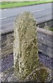
Inscribed Stone with Ordnance Survey Pivot
This 11th or 12th century slab with OS pivot can be found in the garden of No65 Marlas Road. It marks a point 39.011m above mean sea level.
Image: © Adrian Dust
Taken: 10 Nov 2017
0.03 miles
2
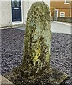
Old Wayside Cross - moved by Marlas Road, Pyle Parish
Groes Siencyn/Jenkins Cross, standing stone by the UC road, in parish of Pyle (Bridgend District), 65 Marlas Road, Pyle, in front garden, South side of road.
To be surveyed
Milestone Society National ID: BRI_PYL
Image: © Milestone Society
Taken: Unknown
0.03 miles
3
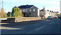
Beach Road, Pyle
Beach Road would be better named Station Road, for it goes nowhere near a beach
but leads to Pyle railway station. Viewed from the corner of Marlas Road.
Image: © Jaggery
Taken: 29 Nov 2012
0.05 miles
4
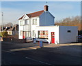
Unnamed shop and matching house, Pyle
The white buildings with red doors are on the north side
of Marlas Road between Beach Road and Mill Road.
Image: © Jaggery
Taken: 29 Nov 2012
0.06 miles
5
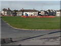
Beach Road and Pandy Crescent houses, Pyle
Viewed across a large grass semicircle from near Pyle RFC's clubhouse. http://www.geograph.org.uk/photo/3251246
Beach Road is on the left.
Image: © Jaggery
Taken: 29 Nov 2012
0.10 miles
6
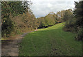
Wooded valley, Pyle
Part of a short and gentle valley around the Afon Cynffig in the Pyle area. The photograph shows some of the wood Coed y Gollen which occupies the valley, as well as a stretch of the public footpath which runs along it.
Image: © eswales
Taken: Unknown
0.10 miles
7
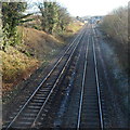
Railway viewed from Marlas Road footbridge, Pyle
A view from this http://www.geograph.org.uk/photo/3243430 footbridge looking towards Pyle railway station http://www.geograph.org.uk/photo/3251359 about 400 metres away.
Image: © Jaggery
Taken: 29 Nov 2012
0.11 miles
8
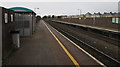
Pyle railway station
Viewed from the platform for trains to Swansea. The footbridge http://www.geograph.org.uk/photo/5410792 behind the camera gives access to the other platform, for trains to Cardiff.
Image: © Jaggery
Taken: 4 Mar 2017
0.11 miles
9
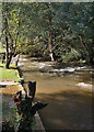
The Afon Cynffig, Pyle
A view looking downstream from beside the disused weir seen in Image The river is full and quite turbulent following recent rainfall, including a spell of persistent, sometimes heavy rain in the twenty four hours before the photograph was taken.
Image: © eswales
Taken: 6 Oct 2012
0.11 miles
10
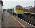
Coradia dmu at Pyle railway station
The Arriva Trains Wales fleet number in view is 175 112, which identifies the train as a member of Class 175 Coradia, a fleet of dmu (diesel multiple unit) passenger trains built from 1999 to 2001 by Alstom, Washwood Heath, Birmingham.
Image: © Jaggery
Taken: 4 Mar 2017
0.11 miles