1
Unnamed shop and matching house, Pyle
The white buildings with red doors are on the north side
of Marlas Road between Beach Road and Mill Road.
Image: © Jaggery
Taken: 29 Nov 2012
0.02 miles
2
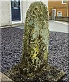
Inscribed Stone with Ordnance Survey Pivot
This 11th or 12th century slab with OS pivot can be found in the garden of No65 Marlas Road. It marks a point 39.011m above mean sea level.
Image: © Adrian Dust
Taken: 10 Nov 2017
0.04 miles
3
Old Wayside Cross - moved by Marlas Road, Pyle Parish
Groes Siencyn/Jenkins Cross, standing stone by the UC road, in parish of Pyle (Bridgend District), 65 Marlas Road, Pyle, in front garden, South side of road.
To be surveyed
Milestone Society National ID: BRI_PYL
Image: © Milestone Society
Taken: Unknown
0.04 miles
4
Raw material for a joke, Marlas Road, Pyle
There could be many reasons why so many men clad in yellow hi-viz jackets
are gathered around a hole in the pavement near the Beach Road junction.
Two facetious thoughts occurred to me:
"Mystery hole appears in pavement. Council officials are looking into it"
"Council workers indignant at press claims of overmanning".
I'm sure you can do better...
Image: © Jaggery
Taken: 29 Nov 2012
0.06 miles
5
Beach Road, Pyle
Beach Road would be better named Station Road, for it goes nowhere near a beach
but leads to Pyle railway station. Viewed from the corner of Marlas Road.
Image: © Jaggery
Taken: 29 Nov 2012
0.07 miles
6
Western boundary of Pyle
The road from North Cornelly reaches Pyle, a large village in Bridgend county borough.
Image: © Jaggery
Taken: 29 Nov 2012
0.07 miles
7
Wooded valley, Pyle
Part of a short and gentle valley around the Afon Cynffig in the Pyle area. The photograph shows some of the wood Coed y Gollen which occupies the valley, as well as a stretch of the public footpath which runs along it.
Image: © eswales
Taken: Unknown
0.08 miles
8
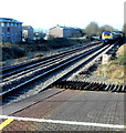
First Great Western train approaches Pyle station at speed
Though Pyle station is on the South Wales main line, trains to and from London Paddington do not stop here. Pyle is served by local trains on the Arriva Trains Wales Swanline (Swansea to Cardiff Central).
Approaching the station at a speed probably near 100mph is a First Great Western train from Swansea to London Paddington. In the lower left corner of the view is the end of the yellow line behind which passengers must stand to avoid the risk of being hit by air turbulence from passing high speed trains.
Image: © Jaggery
Taken: 29 Nov 2012
0.09 miles
9
The Afon Cynffig, Pyle (2)
Looking upstream on one of the stretches of the river which form part of the boundary between Bridgend and Neath Port Talbot County Boroughs.
Image: © eswales
Taken: 6 Oct 2012
0.10 miles
10
The Afon Cynffig, Pyle
A view looking downstream from beside the disused weir seen in
Image The river is full and quite turbulent following recent rainfall, including a spell of persistent, sometimes heavy rain in the twenty four hours before the photograph was taken.
Image: © eswales
Taken: 6 Oct 2012
0.10 miles


