IMAGES TAKEN NEAR TO
Swn Yr Afon, BRIDGEND, CF33 6AJ
Introduction
This page details the photographs taken nearby to Swn Yr Afon, CF33 6AJ by members of the Geograph project.
The Geograph project started in 2005 with the aim of publishing, organising and preserving representative images for every square kilometre of Great Britain, Ireland and the Isle of Man.

There are currently over 7.5m images from over14,400 individuals and you can help contribute to the project by visiting https://www.geograph.org.uk
Image Map
Images are licensed for reuse under creativecommons.org/licenses/by-sa/2.0
Notes
- Clicking on the map will re-center to the selected point.
- The higher the marker number, the further away the image location is from the centre of the postcode.
Image Listing (37 Images Found)
Images are licensed for reuse under creativecommons.org/licenses/by-sa/2.0
Image
Details
Distance
1
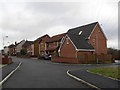
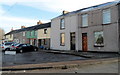
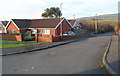
Swn Yr Afon
2000s houses in Kenfig Hill.
Image: © Burgess Von Thunen
Taken: 25 Jan 2012
0.02 miles
2
Crown Road, Kenfig Hill
Viewed from near the Station Road junction, looking past the left turn into a short cul-de-sac, Masons Close. My route here from Commercial Street has been an exclusively royal one, along Prince Road, then Victoria Road and now Crown Road. There is no such option head, because the far end of Crown Road is at the edge of disused quarries.
Image: © Jaggery
Taken: 29 Nov 2012
0.06 miles
3
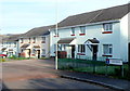
Haulfryn houses, Kenfig Hill
Haulfryn is a cul-de-sac at the northern edge of Kenfig Hill.
Image: © Jaggery
Taken: 29 Nov 2012
0.07 miles
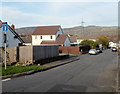
4
Masons Close, Kenfig Hill
Masons Close is a short cul-de-sac of 5 houses on the west side of Crown Road.
Image: © Jaggery
Taken: 29 Nov 2012
0.09 miles
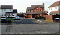
5
Little Station Road, Kenfig Hill
Little Station Road is a short row of houses, located opposite the junction of Station Road,
Crown Road and Victoria Road. The street name sign shows "Leading to Haulfryn". http://www.geograph.org.uk/photo/3262930
Image: © Jaggery
Taken: 29 Nov 2012
0.10 miles
6
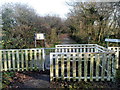
Western entrance to Bedford Park near Kenfig Hill
The fencing is intended to stop motorbikes accessing the park. A small sign on the right shows
NO MOTORBIKES ALLOWED and the same message in Welsh.
Bedford Park, also known as Waun Cimla, is a Site of Special Scientific Interest. It contains the former Cefn Cribwr Ironworks and c40 acres of woodlands and meadows. The park is named after ironmaster John Bedford (1727-1791) who arrived in this area from the English Midlands in the early 1770s. Bedford bought 80 acres of land hereabouts with the plan of establishing an ironworks, (with blast furnace and forge) and the collieries, brickworks and stone quarries needed to support it.
Image: © Jaggery
Taken: 29 Nov 2012
0.10 miles
7
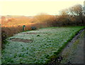
An area of hoar frost on grass at the western edge of Bedford Park near Kenfig Hill
Viewed during a coldish period of weather, when overnight hoar frost remained on the grass here because the direct rays of the sun, at a low angle on a late November afternoon, did not reach the grass.
Image: © Jaggery
Taken: 29 Nov 2012
0.10 miles
8
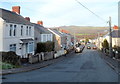
Northern end of Victoria Road, Kenfig Hill
A view along Victoria Road towards the Station Road junction and Crown Road.
Image: © Jaggery
Taken: 29 Nov 2012
0.11 miles
9
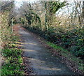
Footpath and cycle route through Bedford Park near Kenfig Hill
A sticker on a pole ahead shows that this is part of National Cycle Network route 4.
Image: © Jaggery
Taken: 29 Nov 2012
0.12 miles
10
Corner of Station Road and Heol-yr-Orsaf, Kenfig Hill
Viewed across Station Road. Heol-yr-Orsaf is a residential cul-de-sac.
The English translation of Heol-yr-Orsaf is Station Road. A 1940s map shows
that the site of the long since demolished Kenfig Hill railway station was nearby.
Image: © Jaggery
Taken: 29 Nov 2012
0.14 miles