IMAGES TAKEN NEAR TO
Pandy Crescent, BRIDGEND, CF33 6AH
Introduction
This page details the photographs taken nearby to Pandy Crescent, CF33 6AH by members of the Geograph project.
The Geograph project started in 2005 with the aim of publishing, organising and preserving representative images for every square kilometre of Great Britain, Ireland and the Isle of Man.

There are currently over 7.5m images from over14,400 individuals and you can help contribute to the project by visiting https://www.geograph.org.uk
Image Map (Loading...)


Getting Data...Please wait
Leaflet Map data © OpenStreetMap
Images are licensed for reuse under creativecommons.org/licenses/by-sa/2.0
Notes
- Clicking on the map will re-center to the selected point.
- The higher the marker number, the further away the image location is from the centre of the postcode.
Image Listing (85 Images Found)
Images are licensed for reuse under creativecommons.org/licenses/by-sa/2.0
Image
Details
Distance
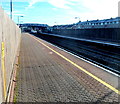
1
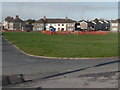
Beach Road and Pandy Crescent houses, Pyle
Viewed across a large grass semicircle from near Pyle RFC's clubhouse. http://www.geograph.org.uk/photo/3251246
Beach Road is on the left.
Image: © Jaggery
Taken: 29 Nov 2012
0.02 miles
2
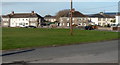
Pandy Crescent, Pyle
Viewed across a large grass semicircle from near Pyle RFC's clubhouse. http://www.geograph.org.uk/photo/3251246
Image: © Jaggery
Taken: 29 Nov 2012
0.02 miles
3
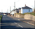
Brynglas Terrace, Pyle
Viewed from the A48 end looking towards Pyle railway station and Pyle rugby club.
Image: © Jaggery
Taken: 29 Nov 2012
0.06 miles
4
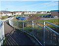
Path from Pyle railway station approaches Beach Road
The c200 metre long access footpath from the station http://www.geograph.org.uk/photo/3251359 approaches Beach Road,
curiously named as it is nowhere near a beach. The station car park is on the right.
Image: © Jaggery
Taken: 29 Nov 2012
0.08 miles
5
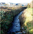
Afon Fach flows towards Pyle railway station
Viewed from the c200 metre long footpath from Beach Road to Pyle railway station.
Afon Fach is Welsh for Little River. The station footbridge http://www.geograph.org.uk/photo/3251350 is in the background.
Image: © Jaggery
Taken: 29 Nov 2012
0.09 miles
6
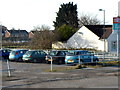
A corner of Pyle railway station car park
Viewed from near the Pyle RFC clubhouse. http://www.geograph.org.uk/photo/3251246 The small car park (capacity 15 cars)
is alongside part of the c200 metre long footpath to Pyle railway station.
Another small car park http://www.geograph.org.uk/photo/5410768 is on the opposite side of the station.
Image: © Jaggery
Taken: 29 Nov 2012
0.09 miles
7
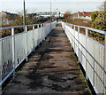
Footpath to Pyle railway station
This is part of the c200 metre long footpath to Pyle railway station
from the station car park http://www.geograph.org.uk/photo/3251281 at the edge of Beach Road.
Image: © Jaggery
Taken: 29 Nov 2012
0.09 miles
8
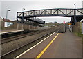
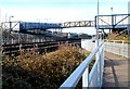
Pyle railway station footbridge
Accessed via zigzag ramps, the footbridge connects the platform for
trains to Swansea on this side with the platform for trains to Cardiff.
Image: © Jaggery
Taken: 4 Mar 2017
0.10 miles
9
Pyle railway station
Viewed from the NW edge of platform 1 looking towards the station footbridge. http://www.geograph.org.uk/photo/3251350
Though Pyle station is on the South Wales main line, trains to and from London Paddington
do not stop here. The station is served by local trains
on the Arriva Trains Wales Swanline (Swansea to Cardiff Central).
Image: © Jaggery
Taken: 29 Nov 2012
0.10 miles
10
Pyle railway station footbridge
Viewed from the c200 metre long footpath from the station car park. http://www.geograph.org.uk/photo/3251281
Image: © Jaggery
Taken: 29 Nov 2012
0.10 miles