IMAGES TAKEN NEAR TO
Gorslas, BRIDGEND, CF33 4NG
Introduction
This page details the photographs taken nearby to Gorslas, CF33 4NG by members of the Geograph project.
The Geograph project started in 2005 with the aim of publishing, organising and preserving representative images for every square kilometre of Great Britain, Ireland and the Isle of Man.

There are currently over 7.5m images from over14,400 individuals and you can help contribute to the project by visiting https://www.geograph.org.uk
Image Map
Images are licensed for reuse under creativecommons.org/licenses/by-sa/2.0
Notes
- Clicking on the map will re-center to the selected point.
- The higher the marker number, the further away the image location is from the centre of the postcode.
Image Listing (49 Images Found)
Images are licensed for reuse under creativecommons.org/licenses/by-sa/2.0
Image
Details
Distance
1
Afon Fach, North Cornelly
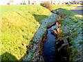
A small tributary of Afon Cynffig named Afon Fach (Welsh for small river) flows towards the bridge conveying it under Marlas Road. Overnight frost on the grass remains where the rays of the late November sun have not yet reached. Lon-y-Cariadon flats http://www.geograph.org.uk/photo/3243174 are in the background.
Image: © Jaggery
Taken: 29 Nov 2012
0.04 miles
2
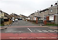
Yr Ynys, North Cornelly
The eastern end of Yr Ynys, housing arranged around a roughly rectangular area on the south side of Ffordd yr Eglwys.
Image: © Jaggery
Taken: 4 Mar 2017
0.05 miles
3
Afon Fach, North Cornelly
Welsh for Little River, Afon Fach is here below the north side of Ffordd yr Eglwys.
Afon Fach is a tributary of Afon Cynffig.
Image: © Jaggery
Taken: 4 Mar 2017
0.06 miles
4
Afon Fach emerges from a culvert, North Cornelly
After flowing underground from the edge of Pyle railway station 225 metres away, Afon Fach emerges from a culvert on the corner of Ffordd yr Eglwys and Lôn-y-Cariadon. Welsh for Little River, Afon Fach is a tributary of Afon Cynffig.
Image: © Jaggery
Taken: 4 Mar 2017
0.08 miles
5
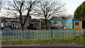
East side of Afon Y Felin Primary School, North Cornelly
Viewed across Marlas Road. The school entrance is from Heol y Parc.
Opened in 1977, the school, for children aged 4-11, has extensive grounds which include a rugby field, an environmental area and an orchard. There are about 90 children enrolled, in one of five classes.
The site includes a Flying Start building for pre-school learning and care for children aged up to 3.
Image: © Jaggery
Taken: 29 Nov 2012
0.08 miles
6
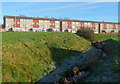
L?n-y-Cariadon flats in North Cornelly
Three-storey flats set back from the north side of Ffordd yr Eglwys.
Image: © Jaggery
Taken: 4 Mar 2017
0.08 miles
7
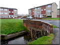
Riverbank flats in North Cornelly
Three-storey Lôn-y-Cariadon flats are on the north bank of Afon Fach. http://www.geograph.org.uk/photo/5301679
Viewed from a Ffordd yr Eglwys bus stop.
Image: © Jaggery
Taken: 4 Mar 2017
0.08 miles
8
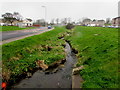
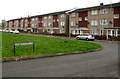
Lon-y-Cariadon, North Cornelly
Lon-y-Cariadon contains 36 flats.
Viewed from Marlas Road along Afon Fach (Welsh for small river).
Image: © Jaggery
Taken: 29 Nov 2012
0.09 miles
9
Ffynnon Wen (western part) in North Cornelly
One of two parallel cul-de-sacs named Ffynnon Wen on the south side of Ffordd yr Eglwys.
Ahead are numbers 1-20 Ffynnon Wen.
Image: © Jaggery
Taken: 4 Mar 2017
0.09 miles
10
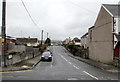
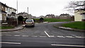
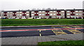
Meadow Street, North Cornelly
Viewed from the corner of Heol Llan looking across the B4283 Heol Fach.
Meadow Street leads to Heol-y-parc about 300 metres ahead.
Image: © Jaggery
Taken: 1 Mar 2017
0.10 miles