1
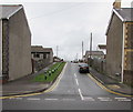
Heol Fach houses, North Cornelly
Southeast of the Greenfield Terrace junction, viewed across the B4283 Heol Fach.
Image: © Jaggery
Taken: 1 Mar 2017
0.01 miles
2
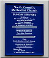
Information and activities board, North Cornelly Methodist Church
On the wall here http://www.geograph.org.uk/photo/5298740 viewed on March 1st 2017. Secular activities shown are line dancing and craft group.
Image: © Jaggery
Taken: 1 Mar 2017
0.02 miles
3
North Cornelly Methodist Church
Located at 5-7 Heol Fach, North Cornelly, the church is part of the Neath Port Talbot Methodist Circuit.
The church website records that in the early 1920s Ebenezer Primitive Methodist Church took root. A group of enthusiastic evangelists from Bethel Primitive Methodist Church in Port Talbot came to Cornelly and held services, sometimes in the local school, sometimes in the open air in the surrounding fields. It was from that fellowship that the present church grew.
The first building was erected in 1924. During the 1940s, it was used as a cinema on Saturday mornings for the local children to view cartoons. A minute in the records of 1952 stated that the use of the church was granted (free of charge) to the Ministry of Food for the distribution of ration books.
In 1966 the building was extended and further amenities were included.
In 2017 the building has a loop induction system and is wheelchair friendly.
Image: © Jaggery
Taken: 1 Mar 2017
0.02 miles
4
North Cornelly Surgery
Medical surgery on the west side of the B4283 Heol Fach in North Cornelly.
Image: © Jaggery
Taken: 1 Mar 2017
0.03 miles
5
Corneli Primary School in North Cornelly
On the north side of Hall Drive. Corneli is the Welsh name of the village known in English as North Cornelly.
Image: © Jaggery
Taken: 1 Mar 2017
0.04 miles
6
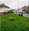
St David's Day daffodils in North Cornelly
On the corner of Heol Dylan and Heol Fach, viewed on March 1st 2017. The exact date of the birth of St David, the patron saint of Wales, is lost in the mists of time. His feast day today commemorates his death in what is now St Davids in Pembrokeshire on March 1st 589 (or perhaps March 1st 601). St David's Day has been celebrated as the national day of Wales since the 12th century.
Image: © Jaggery
Taken: 1 Mar 2017
0.04 miles
7
Wide load through North Cornelly
Travelling southeastwards on the B4283 Heol Fach, past the Greenfield Terrace junction, on March 1st 2017.
A wide load escort car http://www.geograph.org.uk/photo/5299674 is in front of the wide load.
Image: © Jaggery
Taken: 1 Mar 2017
0.04 miles
8
North Cornelly Surgery car park
Viewed across the B4283 Heol Fach. The car park is for the vehicles of surgery staff and blue badge holders only.
Image: © Jaggery
Taken: 1 Mar 2017
0.04 miles
9
Ysgol Ferch o'r Sger
Ysgol Ferch o'r Sger, North Cornelly
Image: © Alan Hughes
Taken: 20 Dec 2015
0.05 miles
10
Greenfield Terrace, North Cornelly
Viewed across the B4283 Heol Fach.
Image: © Jaggery
Taken: 1 Mar 2017
0.05 miles


