IMAGES TAKEN NEAR TO
Plas Heddwch, BRIDGEND, CF33 4LA
Introduction
This page details the photographs taken nearby to Plas Heddwch, CF33 4LA by members of the Geograph project.
The Geograph project started in 2005 with the aim of publishing, organising and preserving representative images for every square kilometre of Great Britain, Ireland and the Isle of Man.

There are currently over 7.5m images from over14,400 individuals and you can help contribute to the project by visiting https://www.geograph.org.uk
Image Map
Images are licensed for reuse under creativecommons.org/licenses/by-sa/2.0
Notes
- Clicking on the map will re-center to the selected point.
- The higher the marker number, the further away the image location is from the centre of the postcode.
Image Listing (65 Images Found)
Images are licensed for reuse under creativecommons.org/licenses/by-sa/2.0
Image
Details
Distance
1
Chapel and cemetery
Located in North Cornelly.
Image: © Chris Shaw
Taken: 26 Jul 2006
0.04 miles
2
Cornelly Cemetery, North Cornelly
On the north side of Ffordd Yr Eglwys.
Image: © Jaggery
Taken: 1 Mar 2017
0.04 miles
3
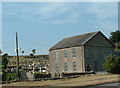
Capel y P
Capel y Pîl, addoldy'r Meddodistiaid Calfinaidd. Adeiladwyd y capel cyntaf yn 1786 ac fe'i hailadeiladwyd yn 1830. Cafodd ei helaethu eto yn 1862. Yn anffodus, fe gaewyd y capel oherwydd gostyngiad yn y nifer a'i mynychai ac mae e eisioes wedi'i werthu.
Capel y Pîl, the meeting house of the local Welsh speaking Calvinist Methodists. First erected in 1786 the chapel was rebuilt in 1830 and enlarged again in 1862. Sadly, due to a dwindling congregation, the chapel was forced to close and it has since been sold.
Image: © Alan Richards
Taken: 16 Feb 2018
0.05 miles
4
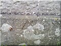
Ordnance Survey Pivot
This OS pivot can be found on the Methodist Chapel. It marks a point 34.412m above mean sea level.
Image: © Adrian Dust
Taken: 18 Aug 2021
0.05 miles
5
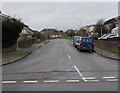
Heol-y-Parc, North Cornelly
From Ffordd yr Eglwys along Heol-y-Parc towards the Hall Drive junction.
Image: © Jaggery
Taken: 1 Mar 2017
0.05 miles
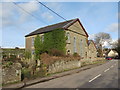
6
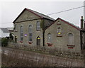
Grade II (star) listed former chapel, Ffordd Yr Eglwys, North Cornelly
The building is for sale in this photo taken on March 1st 2017.
The Coflein website states that Capel-y-Pil/Pyle Methodist Chapel was built in 1786, rebuilt immediately adjacent in 1830 (now the schoolroom) and rebuilt on the original site in 1862. The present chapel, dated 1862, is built in the Simple Round-Headed style with a gable entry plan, two storeys and tall windows.
The chapel was Grade II (star) listed in 1998 as a largely unaltered and handsome mid 19th century chapel which had retained its original character both externally and internally.
Image: © Jaggery
Taken: 1 Mar 2017
0.05 miles
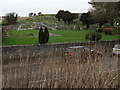
7
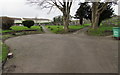
Path junction in Cornelly Cemetery, North Cornelly
Viewed from the cemetery main entrance. http://www.geograph.org.uk/photo/5538514
Image: © Jaggery
Taken: 1 Mar 2017
0.05 miles
8
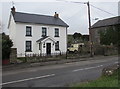
White house, Ffordd Yr Eglwys, North Cornelly
A former chapel is on the right. http://www.geograph.org.uk/photo/5538480
Image: © Jaggery
Taken: 1 Mar 2017
0.05 miles
9
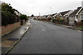
East along Hall Drive, North Cornelly
Towards the Heol-y-parc junction.
Image: © Jaggery
Taken: 1 Mar 2017
0.05 miles
10
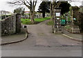
Main entrance to Cornelly Cemetery, North Cornelly
From the north side of Ffordd Yr Eglwys.
Image: © Jaggery
Taken: 1 Mar 2017
0.06 miles