IMAGES TAKEN NEAR TO
Ffordd Newydd, BRIDGEND, CF33 4HQ
Introduction
This page details the photographs taken nearby to Ffordd Newydd, CF33 4HQ by members of the Geograph project.
The Geograph project started in 2005 with the aim of publishing, organising and preserving representative images for every square kilometre of Great Britain, Ireland and the Isle of Man.

There are currently over 7.5m images from over14,400 individuals and you can help contribute to the project by visiting https://www.geograph.org.uk
Image Map (Loading...)


Getting Data...Please wait
Leaflet Map data © OpenStreetMap
Images are licensed for reuse under creativecommons.org/licenses/by-sa/2.0
Notes
- Clicking on the map will re-center to the selected point.
- The higher the marker number, the further away the image location is from the centre of the postcode.
Image Listing (100 Images Found)
Images are licensed for reuse under creativecommons.org/licenses/by-sa/2.0
Image
Details
Distance
1
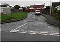
Ffordd Newydd, North Cornelly
Cul-de-sac on the south side of Hall Drive.
Image: © Jaggery
Taken: 1 Mar 2017
0.01 miles
2
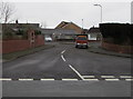
Southern arm of Hall Drive, North Cornelly
Aligned at right angles to the main east-west course of Hall Drive.
Image: © Jaggery
Taken: 1 Mar 2017
0.03 miles
3
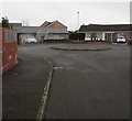
Hall Drive turning circle, North Cornelly
At the southern end of this http://www.geograph.org.uk/photo/5298510 side arm of Hall Drive.
Image: © Jaggery
Taken: 1 Mar 2017
0.03 miles
4
Thomas Crescent houses, North Cornelly
The houses on the north side of Thomas Crescent face the back gardens of School Terrace houses.
New House Inn http://www.geograph.org.uk/photo/5299986 is behind the camera.
Image: © Jaggery
Taken: 1 Mar 2017
0.05 miles
5
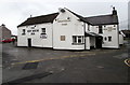
New House Inn in North Cornelly
Pub viewed across Thomas Crescent.
Image: © Jaggery
Taken: 1 Mar 2017
0.05 miles
6
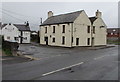
Adjacent pubs in Thomas Crescent, North Cornelly
The former Cornelly Arms on the right is boarded up and derelict on March 1st 2017.
The New House Inn http://www.geograph.org.uk/photo/5299986 on the left is open for business.
Image: © Jaggery
Taken: 1 Mar 2017
0.05 miles
7
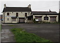
Derelict former Cornelly Arms pub in North Cornelly
Boarded-up former pub viewed on March 1st 2017.
Image: © Jaggery
Taken: 1 Mar 2017
0.06 miles
8
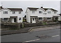
White houses, Fairfield, North Cornelly
The Fairfield name sign on the right is near the corner of Thomas Crescent.
Image: © Jaggery
Taken: 1 Mar 2017
0.06 miles
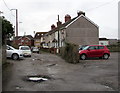
9
School House Close, North Cornelly
Cul-de-sac on the south side of Hall Drive.
Image: © Jaggery
Taken: 1 Mar 2017
0.07 miles
10
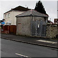
Western Power Distribution electricity substation, School Terrace, North Cornelly
The substation identifier is North Cornelly 56-3457.
Image: © Jaggery
Taken: 1 Mar 2017
0.07 miles