IMAGES TAKEN NEAR TO
Bryn Yr Orsaf, BRIDGEND, CF33 4HE
Introduction
This page details the photographs taken nearby to Bryn Yr Orsaf, CF33 4HE by members of the Geograph project.
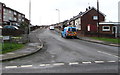
The Geograph project started in 2005 with the aim of publishing, organising and preserving representative images for every square kilometre of Great Britain, Ireland and the Isle of Man.

There are currently over 7.5m images from over14,400 individuals and you can help contribute to the project by visiting https://www.geograph.org.uk
Image Map
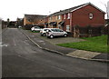
Images are licensed for reuse under creativecommons.org/licenses/by-sa/2.0
Notes
- Clicking on the map will re-center to the selected point.
- The higher the marker number, the further away the image location is from the centre of the postcode.
Image Listing (74 Images Found)
Images are licensed for reuse under creativecommons.org/licenses/by-sa/2.0
Image
Details
Distance
1
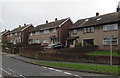
Bryn yr Orsaf, North Cornelly
Cul-de-sac near an entrance to Pyle railway station. A railway perimeter fence is on the left.
Image: © Jaggery
Taken: 4 Mar 2017
0.02 miles
2
Wales & West Utilities gas installation, Ffordd yr Eglwys, North Cornelly
Near the corner of Bryn-yr-Orsaf and Pyle railway station.
Image: © Jaggery
Taken: 4 Mar 2017
0.03 miles
3
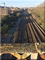
Railway at Pyle
The main Paddington to Swansea line at Pyle.
Image: © Alan Hughes
Taken: 3 Jan 2017
0.03 miles
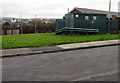
4
Small bus shelter alongside Ffordd yr Eglwys, North Cornelly
This side of the road for buses to Porthcawl.
Image: © Jaggery
Taken: 1 Mar 2017
0.04 miles
5
West along Ael y Bryn, North Cornelly
Ael y Bryn is a cul-de-sac extending for about 250 metres from the west side of Ffordd yr Eglwys.
Image: © Jaggery
Taken: 1 Mar 2017
0.05 miles
6
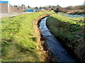
Afon Fach flows towards Pyle railway station footpath
Viewed from the c200 metre long footpath from Beach Road to Pyle railway station.
Afon Fach is Welsh for Little River.
Image: © Jaggery
Taken: 29 Nov 2012
0.05 miles
7
Three-storey houses, Ffordd yr Eglwys, North Cornelly
Front doors and garages built into the houses are on the ground floor.
Image: © Jaggery
Taken: 1 Mar 2017
0.06 miles
8
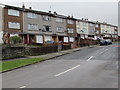
Ffordd yr Eglwys semis, North Cornelly
Semi-detached houses on the south side of Ffordd yr Eglwys near Pyle railway station.
Image: © Jaggery
Taken: 4 Mar 2017
0.06 miles
9
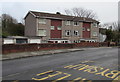
Three-storey flats, Ffordd yr Eglwys, North Cornelly
Set back 10 metres from the east side of the road named Ffordd yr Eglwys.
Image: © Jaggery
Taken: 1 Mar 2017
0.07 miles
10
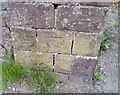
Ordnance Survey Cut Mark
This OS cut mark can be found on the gatepost leading to the railway footbridge. It marks a point 37.189m above mean sea level.
Image: © Adrian Dust
Taken: 18 Aug 2021
0.08 miles