IMAGES TAKEN NEAR TO
Tyle Glas, BRIDGEND, CF33 4ED
Introduction
This page details the photographs taken nearby to Tyle Glas, CF33 4ED by members of the Geograph project.
The Geograph project started in 2005 with the aim of publishing, organising and preserving representative images for every square kilometre of Great Britain, Ireland and the Isle of Man.

There are currently over 7.5m images from over14,400 individuals and you can help contribute to the project by visiting https://www.geograph.org.uk
Image Map
Images are licensed for reuse under creativecommons.org/licenses/by-sa/2.0
Notes
- Clicking on the map will re-center to the selected point.
- The higher the marker number, the further away the image location is from the centre of the postcode.
Image Listing (42 Images Found)
Images are licensed for reuse under creativecommons.org/licenses/by-sa/2.0
Image
Details
Distance
1
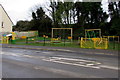
Yellow and green play area, Ffordd Yr Eglwys, North Cornelly
Built in the second decade of the 21st century, viewed in March 2017.
Neither this playground nor adjacent houses appear in a June 2011 Google Earth Street View.
Image: © Jaggery
Taken: 1 Mar 2017
0.04 miles
2
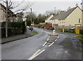
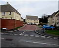
Bend in Ffordd Yr Eglwys, North Cornelly
The houses on the right were built in the second decade of the 21st century.
Image: © Jaggery
Taken: 1 Mar 2017
0.05 miles
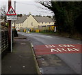
3
Warning sign - humps for 145 yards, Ffordd Yr Eglwys, North Cornelly
The text is also in Welsh. The houses and playground were built in the second decade of the 21st century.
Image: © Jaggery
Taken: 1 Mar 2017
0.05 miles
4
Warning sign - playground, Ffordd Yr Eglwys, North Cornelly
On the approach to this http://www.geograph.org.uk/photo/5538441 playground. The text on the sign is also in Welsh.
Image: © Jaggery
Taken: 1 Mar 2017
0.05 miles
5
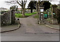
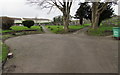
Main entrance to Cornelly Cemetery, North Cornelly
From the north side of Ffordd Yr Eglwys.
Image: © Jaggery
Taken: 1 Mar 2017
0.06 miles
6
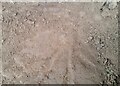
Ordnance Survey Rivet
This OS rivet can be found on the base of the SE parapet of the railway bridge. It marks a point 43.605m above mean sea level.
Image: © Adrian Dust
Taken: 18 Aug 2021
0.06 miles
7
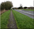
Grass-edged path in North Cornelly
Between Ffordd Yr Eglwys, out of shot on the left, and the unnamed main road.
Image: © Jaggery
Taken: 1 Mar 2017
0.06 miles
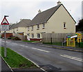
8
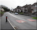
Ffordd yr Eglwys semis, North Cornelly
Semi-detached houses viewed across speed bumps on the road named Ffordd yr Eglwys.
Image: © Jaggery
Taken: 1 Mar 2017
0.06 miles
9
Trem Capel y Pil, North Cornelly
Recently-built cul-de-sac on the east side of Ffordd yr Eglwys, viewed in March 2017.
Image: © Jaggery
Taken: 1 Mar 2017
0.06 miles
10
Path junction in Cornelly Cemetery, North Cornelly
Viewed from the cemetery main entrance. http://www.geograph.org.uk/photo/5538514
Image: © Jaggery
Taken: 1 Mar 2017
0.07 miles