IMAGES TAKEN NEAR TO
Heol Bryn, BRIDGEND, CF33 4DE
Introduction
This page details the photographs taken nearby to Heol Bryn, CF33 4DE by members of the Geograph project.
The Geograph project started in 2005 with the aim of publishing, organising and preserving representative images for every square kilometre of Great Britain, Ireland and the Isle of Man.

There are currently over 7.5m images from over14,400 individuals and you can help contribute to the project by visiting https://www.geograph.org.uk
Image Map
Images are licensed for reuse under creativecommons.org/licenses/by-sa/2.0
Notes
- Clicking on the map will re-center to the selected point.
- The higher the marker number, the further away the image location is from the centre of the postcode.
Image Listing (18 Images Found)
Images are licensed for reuse under creativecommons.org/licenses/by-sa/2.0
Image
Details
Distance
1

Llwybr yn gadael heol / Path exits a road
Ar y chwith mae llwybr troed a llwybr beicio yn gadael yr heol.
On the left a path and cycle path exits the road.
Image: © Alan Richards
Taken: 21 Nov 2023
0.13 miles
2

Llwybr ar lan afon / A path above a river
Llwybr troed a llwybr beicio ar lan afon yn mynd heibio i anhedd-dai.
A footpath and cycle path above a river goes past some properties.
Image: © Alan Richards
Taken: 21 Nov 2023
0.13 miles
3

Llwybr yn cyrraedd yr heol / Path approaching the road
Llwybr troed cyhoeddus yn cyrraedd Heol Fach.
A public footpath joins Heol Fach (trans. small road).
Image: © Alan Richards
Taken: 21 Nov 2023
0.13 miles
4
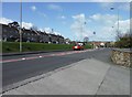
North Cornelly : Heol Fach B4283
A road heading through the town of Heol Fach.
Image: © Lewis Clarke
Taken: 23 Mar 2014
0.16 miles
5
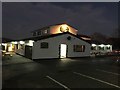
Green Acres Motel
The Green Acres, North Cornelly, at night.
Image: © Alan Hughes
Taken: 30 Nov 2016
0.19 miles
6

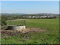
North Cornelly : Ffordd Mawdlam
Looking down to the road on the outskirts of North Cornelly.
Image: © Lewis Clarke
Taken: 23 Mar 2014
0.19 miles
9
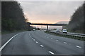
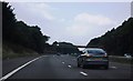
Bridgend District : The M4 Motorway
The M4 Motorway heading westbound through the Bridgend area.
Image: © Lewis Clarke
Taken: 10 Apr 2014
0.20 miles
10
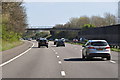
Bridgend District : The M4 Motorway
The M4 Motorway heading eastbound as it passes through the Bridgend area.
Image: © Lewis Clarke
Taken: 11 Apr 2014
0.21 miles