IMAGES TAKEN NEAR TO
Tranch Pyle, BRIDGEND, CF33 4AB
Introduction
This page details the photographs taken nearby to CF33 4AB by members of the Geograph project.
The Geograph project started in 2005 with the aim of publishing, organising and preserving representative images for every square kilometre of Great Britain, Ireland and the Isle of Man.

There are currently over 7.5m images from over14,400 individuals and you can help contribute to the project by visiting https://www.geograph.org.uk
Image Map (Loading...)


Getting Data...Please wait
Leaflet Map data © OpenStreetMap
Images are licensed for reuse under creativecommons.org/licenses/by-sa/2.0
Notes
- Clicking on the map will re-center to the selected point.
- The higher the marker number, the further away the image location is from the centre of the postcode.
Image Listing (7 Images Found)
Images are licensed for reuse under creativecommons.org/licenses/by-sa/2.0
Image
Details
Distance
3
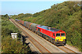
Stormy Down
Swansea to Cardiff main line near Stormy.
Image: © Wayland Smith
Taken: 18 Sep 2019
0.07 miles
4
View from a Cardiff-Swansea train - lineside hut and speed limit
Image: © Nigel Thompson
Taken: 27 Jan 2017
0.07 miles
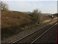
5

Making tracks
Picture of the main Swansea to Paddington railway line which runs through South Wales.
Image: © Martin Edwards
Taken: 14 Sep 2007
0.17 miles
6
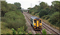
Single car train on South Wales Main Line near Kenfig Hill
A train comprising a single car, numbered 153312, heads towards Bridgend.
Image: © eswales
Taken: Unknown
0.22 miles
7
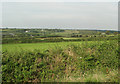
A view to the south of Cefn Cribwr
Looking towards the Cefn Cribwr Ridge over a gentle agricultural valley drained by Nant Ffornwg. The picture was taken towards the western end of a bridleway at the northern edge of Stormy Down.
Image: © eswales
Taken: Unknown
0.24 miles