IMAGES TAKEN NEAR TO
Bakery Lane, CARDIFF, CF3 2LF
Introduction
This page details the photographs taken nearby to Bakery Lane, CF3 2LF by members of the Geograph project.
The Geograph project started in 2005 with the aim of publishing, organising and preserving representative images for every square kilometre of Great Britain, Ireland and the Isle of Man.

There are currently over 7.5m images from over14,400 individuals and you can help contribute to the project by visiting https://www.geograph.org.uk
Image Map
Images are licensed for reuse under creativecommons.org/licenses/by-sa/2.0
Notes
- Clicking on the map will re-center to the selected point.
- The higher the marker number, the further away the image location is from the centre of the postcode.
Image Listing (40 Images Found)
Images are licensed for reuse under creativecommons.org/licenses/by-sa/2.0
Image
Details
Distance
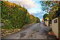
1
Springfields in Marshfield
Springfields is a cul-de-sac on the east side of Marshfield Road.
The sign on the right shows no motor vehicles except for access.
Image: © Jaggery
Taken: 21 Mar 2019
0.09 miles
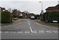
2
Bakery Lane, Marshfield
Private road on the east side of Marshfield Road near the Castleton boundary.
Image: © Jaggery
Taken: 21 Mar 2019
0.10 miles
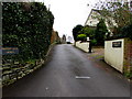
3
Castleton : Bakery Lane
Looking along Bakery Lane off Marshfield Road.
Image: © Lewis Clarke
Taken: 14 Nov 2018
0.11 miles
4
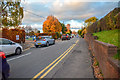
Castleton : Marshfield Road
Looking along Marshfield Road.
Image: © Lewis Clarke
Taken: 14 Nov 2018
0.11 miles
5
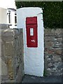
Victorian Postbox at Castleton
Situated in Marshfield Road.
Image: © Robin Drayton
Taken: 24 Jul 2008
0.11 miles
7
Dilmar, 31 Marshfield Road, Castleton
Set into the wall in front of Dilmar is a Victorian-era postbox http://www.geograph.org.uk/photo/900350
Image: © Jaggery
Taken: 22 Oct 2009
0.11 miles
8
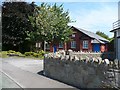
YMFS Institute, Castleton
At the beginning of the 20th century many local young men used to meet at a coffee house in Castleton for the purpose of reading and literature discussion. They called themselves the Young Men's Friendly Society. In 1923 Lord Tredegar made a gift of the ground and the money for the erection of the brick building seen here for the use of these young men.
Still known as the YMFS Institute, it is now used as a village hall, providing facilities for meetings, concerts, annual fairs, and fetes. The premises can be hired for occasions such as wedding and birthday parties.
Image: © Jaggery
Taken: 22 Oct 2009
0.11 miles
9
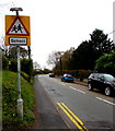
Warning sign - School, Marshfield Road, Marshfield
On the corner of Bakery Lane on the northern approach to Marshfield Primary School. https://www.geograph.org.uk/photo/6093089
Image: © Jaggery
Taken: 21 Mar 2019
0.11 miles
10
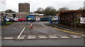
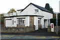
School gates, Marshfield
Marshfield Primary School gates on the west side of Marshfield Road.
Notices on the gates in March 2019 show STAFF PARKING ONLY - Strictly No Entry.
Image: © Jaggery
Taken: 21 Mar 2019
0.11 miles