IMAGES TAKEN NEAR TO
Pant Hirwaun, BRIDGEND, CF32 9YJ
Introduction
This page details the photographs taken nearby to Pant Hirwaun, CF32 9YJ by members of the Geograph project.
The Geograph project started in 2005 with the aim of publishing, organising and preserving representative images for every square kilometre of Great Britain, Ireland and the Isle of Man.

There are currently over 7.5m images from over14,400 individuals and you can help contribute to the project by visiting https://www.geograph.org.uk
Image Map
Images are licensed for reuse under creativecommons.org/licenses/by-sa/2.0
Notes
- Clicking on the map will re-center to the selected point.
- The higher the marker number, the further away the image location is from the centre of the postcode.
Image Listing (4 Images Found)
Images are licensed for reuse under creativecommons.org/licenses/by-sa/2.0
Image
Details
Distance
1
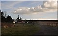
Bridgend District : Small Track
A small track heading into the countryside.
Image: © Lewis Clarke
Taken: 23 Mar 2014
0.06 miles
2
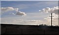
Bridgend District : Grassy Field
A grassy field in the Bridgend District.
Image: © Lewis Clarke
Taken: 23 Mar 2014
0.06 miles
3
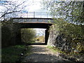
Bridge over GWR trackbed
Great Western Railway between Llanharan & Brynmenyn
Image: © Ray Durrant
Taken: 16 Apr 2012
0.17 miles
4
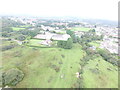
Bryncethin Trackbed, through Bryncethin
On the Bryncethin branch, connecting the Ogmore Valley Line with the Cardiff-Ogmore line (later Great Western) we look west over the village (now suburb of Bridgend) which names the branch.
More details in the post which supports this submission. https://tinyurl.com/y5gqdont
All drone work is performed under a registered drone pilots license.
Image: © Trevor Edward Streeter
Taken: 15 Sep 2020
0.24 miles