IMAGES TAKEN NEAR TO
Heol Persondy, BRIDGEND, CF32 9TF
Introduction
This page details the photographs taken nearby to Heol Persondy, CF32 9TF by members of the Geograph project.
The Geograph project started in 2005 with the aim of publishing, organising and preserving representative images for every square kilometre of Great Britain, Ireland and the Isle of Man.

There are currently over 7.5m images from over14,400 individuals and you can help contribute to the project by visiting https://www.geograph.org.uk
Image Map
Images are licensed for reuse under creativecommons.org/licenses/by-sa/2.0
Notes
- Clicking on the map will re-center to the selected point.
- The higher the marker number, the further away the image location is from the centre of the postcode.
Image Listing (201 Images Found)
Images are licensed for reuse under creativecommons.org/licenses/by-sa/2.0
Image
Details
Distance
1
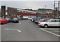
Bridgend Pupil Referral Unit, Aberkenfig
Viewed from Heol Persondy. The Pupil Referral Unit provides support for pupils from Key Stages 3 & 4. This site is for Key Stage 3 pupils. The Key Stage 4 site is in Pyle.
Image: © Jaggery
Taken: 27 Mar 2013
0.01 miles
2
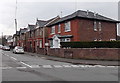
Heol Persondy houses, Aberkenfig
Viewed from the corner of St Bride's Road and Pandy Park.
Image: © Jaggery
Taken: 27 Mar 2013
0.03 miles
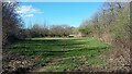
3
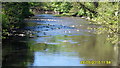
River scene, Aberkenfig
Note the 2 herons looking for fish
Image: © Colin Prosser
Taken: 23 May 2010
0.03 miles
4
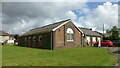
Aberkenfig village
Len Evans former boys club Aberkenfig
Image: © Colin Prosser
Taken: 20 Aug 2022
0.04 miles
5
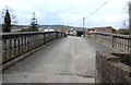
Across the Ogmore towards Tondu Primary School, Aberkenfig
Viewed along Heol Persondy across an Ogmore River bridge http://www.geograph.org.uk/photo/3812876 towards this http://www.geograph.org.uk/photo/3387490 school.
Image: © Jaggery
Taken: 27 Mar 2013
0.04 miles
6
Aberkenfig
Aberkenfig, across the fields alongside river Ogmore to Pandy bridge
Image: © Colin Prosser
Taken: 5 Apr 2021
0.04 miles
7
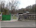
Restricted access gate near the Ogmore River in Aberkenfig
The gate is alongside Heol Persondy at the edge of this http://www.geograph.org.uk/photo/3812858 bridge. The notice on the gate states that access (to a bank of the Ogmore) is for Ogmore Angling Association members only.
Image: © Jaggery
Taken: 27 Mar 2013
0.04 miles
8
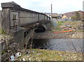
East side of Heol Persondy river bridge, Aberkenfig
The bridge http://www.geograph.org.uk/photo/3812858 spans the Ogmore River.
Image: © Jaggery
Taken: 27 Mar 2013
0.04 miles
9
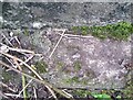
Ordnance Survey Rivet
This OS rivet can be found at the base of the NE parapet of the bridge. It marks a point 38.808m above mean sea level.
Image: © Adrian Dust
Taken: 5 Sep 2021
0.05 miles
10
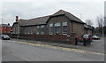
Tondu Primary School, Aberkenfig
Located in Heol Persondy, Aberkenfig. A modern name board shows Tondu Primary School, which confused this first-time visitor to the area, because Tondu is located several hundred metres to the north. An old plaque on the wall in the middle of the view shows
GLAMORGAN COUNTY COUNCIL
1915
ABERKENFIG COUNCIL SCHOOL.
Image: © Jaggery
Taken: 27 Mar 2013
0.05 miles